Hi, I’m Captain Devin and I believe in “fishing smarter”. To Fish Smarter is to embrace a philosophy nested inside the world of inshore fishing.
For many of us, it is to painful to sit under an umbrella and watch a cork all day.
We want to enjoy hunting fish and finding the bite, to experience those “Aha!” moments when we learn something new, to become masters of our trade and of the marsh.
So I Fish Smarter.
You can Fish Smarter by finding and recognizing tidelines to catch specks and reds.
I will show you how I use Google Earth to locate this phenomena.
Catch Speckled Trout and Redfish by Fishing Tidelines
What are tidelines?
Tidelines are formed when current flows around a point or along a shoreline.
From a vantage point above the water, especially the sky, they can be seen as long lines stretched in the direction the water is flowing.
See the picture below to better understand.

You can see those tidelines because that is where water is flowing the heaviest.
Trout may not actually hold on these lines, but just inside it between the tideline and the shore.
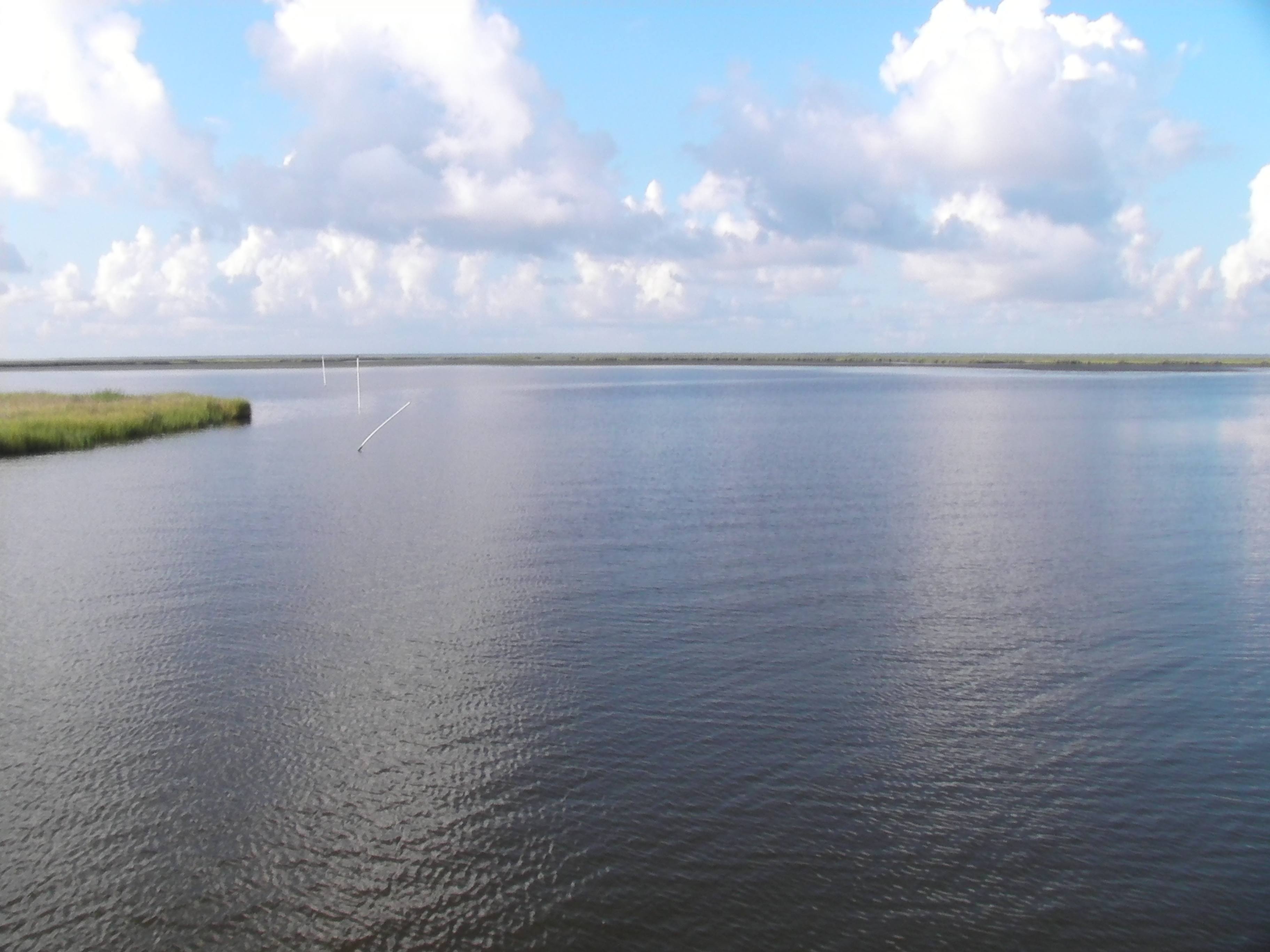
In the above picture you can see a tideline that is running off the shore into another body of water.
You can see the PVC pipes marking the oyster lease and it is those pipes or “oyster sticks” that indicate there is a an oyster bed underwater.
Oysters are filter feeders. It makes sense you would find them in the same spot tidelines occur.
Oysters are filter feeders and need that current to survive, grow and be plentiful.
Tidelines are just as important to other fishermen.
Crabbers line their traps on tidelines because crabs travel along them with the current.
Understand that if you can’t see the tideline from your boat, but you know the water is moving, you can use crab traps and oyster sticks as an indicator to where you need to fish.
Tide lines are visible from the sky, but not always from your boat.
You may have been running over loads of trout without even knowing it.
It comes as no surprise that “find the tide line” has become the name of the game.
Why are these tidelines so important?
Speckled trout and redfish can’t see what we do above the water’s surface.
Their world is a little different from ours and they will make decisions based on what’s underwater.
One thing influencing their behavior is the presence of baitfish, especially shrimp.
If you have ever seen a speckled trout swim, you know they dart around like missiles.
Shrimp are not so quick and remain at the mercy of the current once they are adrift.
Apparently, this is at the disadvantage of the shrimp.
See for yourself here:
So as a tide is falling, all the water will be flowing towards those main arteries of the marsh.
With it will be drifting shrimp and other tasty baitfish speckled trout and redfish enjoy.
Moving water essentially “forms” the baitfish and will consistently rake them across the same area.
Speckled trout and redfish know to stack on these areas and await their meals. It is a cycle that happens every day.
Using Google Earth to Find Tidelines
You can see evidence of this bait cycle on Google Earth. It is a dead giveaway.
Note: If you are not familiar with Google Earth and how to use it, then you should read Use Google Earth to Create Custom GPS Routes for Fishing.
Use the Time Slider to find where this bait will be, and then go fish it under favorable conditions.
Now this is where Google Earth and its Time Slider comes into play.
Go ahead, open up Google Earth and follow along. Move to an area in the marsh with various intersections, mouths and cuts.
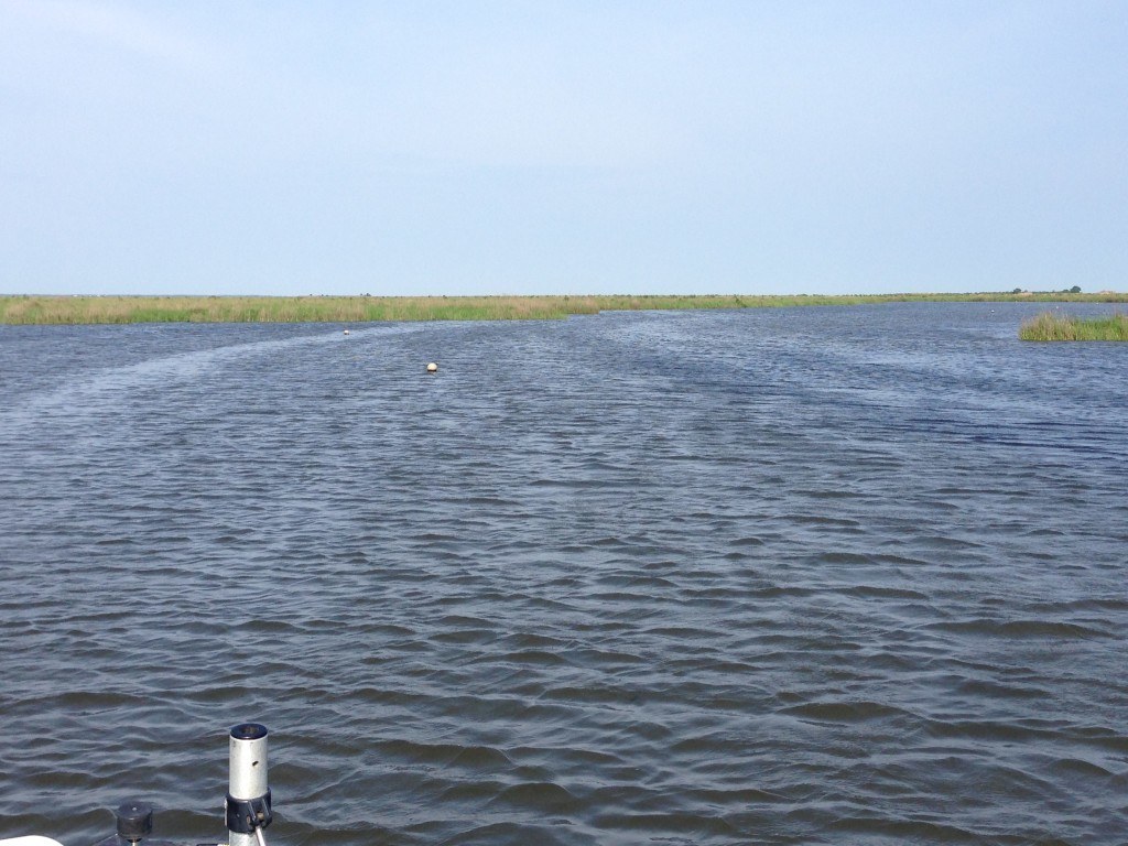
Now scroll through various dates and look for any water rips or tidelines.
Here are a few:


See what I am talking about?
You can get an idea as to what areas will have the right moving water.
Is it a rising or falling tide?
Picking out a spot with a tide line and running to it first thing would be a knee-jerk reaction. Don’t do that!
You have to know if the tide was rising or falling when the satellite image was taken.
Trying to fish a “rising tide” tideline you saw on Google Earth when the tide is falling is a futile effort. You probably won’t catch anything.
Instead, look at the direction the tideline flows to determine whether the tide was rising or falling.
It’s pretty easy to see which way water is flowing on a satellite image.
If it is flowing towards the Gulf of America, then it is a falling tide.
If it is flowing away from the Gulf and towards the inside of the marsh, it is a rising tide.
You need to locate a lot of tidelines to try in order to find the one that is a consistent hot spot.
Where should you cast?
Understand that where you should cast on a tideline can be a little tricky.
You want to try fishing just inside the tideline, but if you don’t get anything there it is worth your time to try other parts of the tideline.
After all, you have an unlimited amount of casts and there is virtue in trying. Experimentation is key!
If you don’t try you will never know if fish were really there or not.