How do we find deep holes for speckled trout? These are really productive fishing spots worth your time, but the fact of the matter is that Louisiana’s coast is a big place.
So how do you know where to go?
In this guide we will take a look at how to locate deep water that speckled trout like to use, and we will do that with 21st century technology, a little practical fishing know-how and some real life examples.
Why do speckled trout go to deep water to begin with?
We already know why speckled trout ferret out deep water, and that’s to seek refuge from harsh conditions.
If this concept is new to you, then I strongly suggest checking out my previous guide on why speckled trout seek deep water, then returning here to learn how to find them.
Knowing why speckled trout seek deep holes will give you an idea when to fish them, and will enable you to understand the content of this guide much better.
So, getting back on track:
In order to really know how to find deep holes for speckled trout (or any gamefish that would use them), we must define what exactly a deep hole is and understand how they are formed in the first place.
What is a "deep hole"?
A deep hole is a body of water — or a part of a body of water — that is relatively deeper than the surrounding area.
Examples include, but are not limited to: bends in bayous, canals, dredge holes, passes and more.
Now, the term “deep hole” is somewhat of a misnomer, because not all “deep holes” on Louisiana’s coast are shaped like a hole.
In fact, they tend to be shaped more like tubs or swimming pools, but can take many different forms. The key defining feature is that they are relatively deeper than the surrounding area.
No, this is not a specific depth, such as a fixed number like 10 feet or 25 feet. It’s relative.
A good example of relative depth would be 10-12 feet deep surrounded by marsh that is 3-5 feet deep.
Or it could be 3-5 feet if the surrounding water is 1-2 feet.
So you see how a deep hole is relative, and not absolute.
How are deep holes formed?
Deep holes are either formed naturally or artificially, and natural deep holes are formed by the movement of water.
Anywhere water flows a lot, the depth tends to be deeper.
This is because faster current will dig out the bottom, making it deeper. This effect is called “scouring” and we see it take place in major passes and main bayous.
Understanding scouring is key to know how to find deep holes for speckled trout.
The ultimate example of scouring can be found in the Mississippi River, where she is upwards of 200ft deep by the French Quarter in New Orleans.
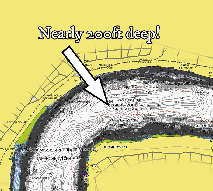
This 200ft depth is located in a bend. Bends tend to create deep holes because the sudden change in direction causes water to scour out the bottom.
The French Quarter bend is about 90 degrees, which is a pretty sharp turn.
So, let's apply this formula elsewhere to find deep holes for speckled trout.
In places where we see the same bends, we see deep holes, too. This bend in Bayou Biloxi is a great example.
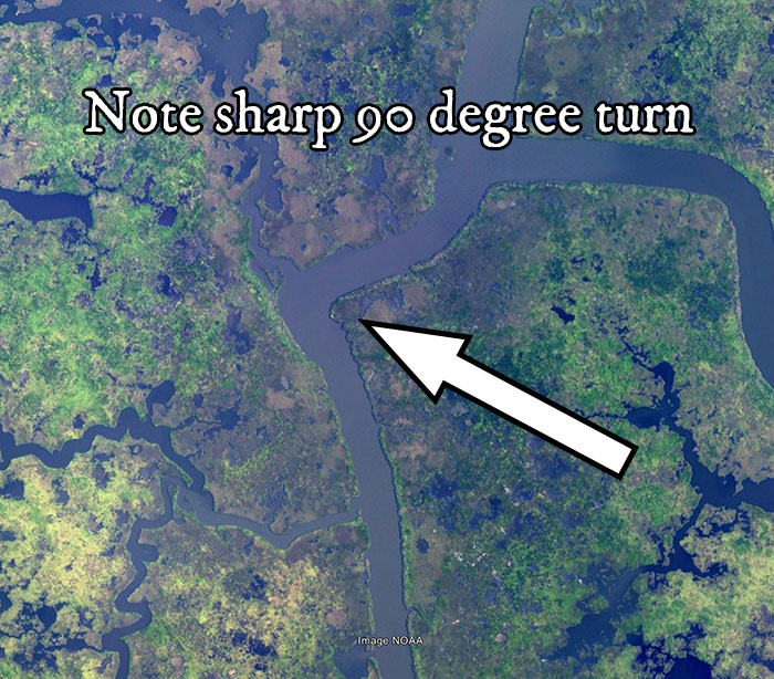
Whereas the rest of the bayou runs some nine to eleven feet deep, it’s well over 20ft deep here.
You can use this bend in Bayou Biloxi as an example of how to find deep holes for speckled trout in other places along Louisiana's coast, too.
But deep bends aren't the only thing to look for!
Another good example are pinch points, or any where water has to flow faster. This bayou between these two ponds is an excellent example.
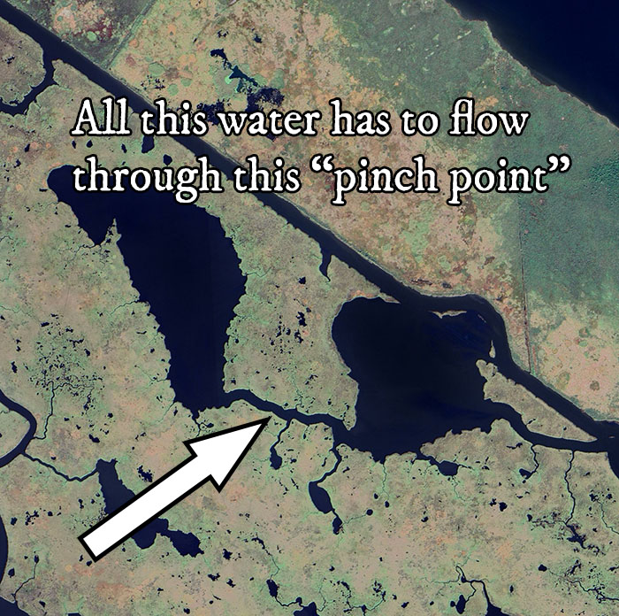
Those ponds run 1-3 feet deep, but that bayou is 9-11 feet deep. Do you think speckled trout stack in there when the conditions take a dump? Yes, they do.
So, places where water flows the most will produce deeper depths. Places where water does not flow at all is where we see shallower depths.
This understanding is critical to find deep holes for speckled trout.
Man-Made Deep Holes
Next we have deep holes that are man-made.
These usually come in the form of anything that has been dredged, which is a $10 word describing the action of making water deeper by use of mechanical means.
This can be done with an excavator to literally scoop out the bottom and haul the spoil onto land, or that dirt could be removed with a large pump located off of the shore in open water.
Sometimes you see both put to work, and they can be used to build canals for navigation or borrow pits dug out to build land.
Knowing where this has taken place in the past is key to find deep holes for speckled trout, but those being dredged now will be worth fishing in the future.
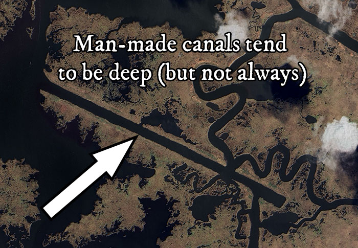
A good example of a deep canal would be this one off Bayou Biloxi; lots of speckled trout can be had there when the conditions are right.
A good example of a dredge hole would be Geoghegan Canal. Not the canal itself, but the pond just off of it.
If memory serves me right (and feel free to correct me in the comments below) this pond was dredged out sometime in the late 1970s.
I could be wrong, I’m just remembering this off the top of my head.
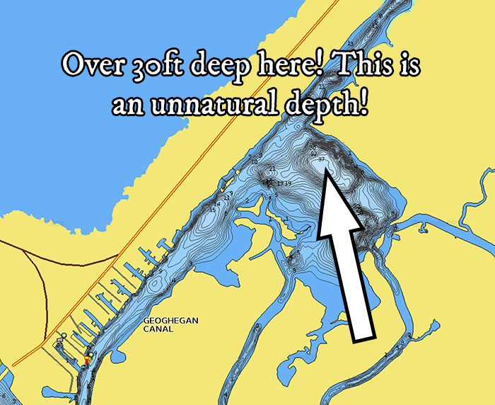
Anyway, if you visit this pond, you will see that it’s well over 30 feet deep.
That depth is not there because water naturally flows through it, like what we saw in Bayou Biloxi and the Mississippi River.
It’s there because it was dredged to — I assume — build land along Highway 90.
So now that you have an idea as to how deep holes are formed, both natural and man-made, let’s look at how to find them from scratch.
How To Find Deep Holes For Speckled Trout
There are two tools that I recommend: Google Earth Desktop and Navionics, and we will get started with Google Earth.
Whoa! Quick Time Out!
To be clear, I mean Google Earth Desktop or "GED" for short. Not Google Maps.
Google Maps is not made for the heavy-lifting that GED can do for inshore anglers like you and me.
Google Maps is made for soccer moms looking for the nearest PJ’s before picking up the kids from school.
Big difference.
And, unfortunately, the only way you can use GED to find deep holes for speckled trout is on a desktop or laptop computer.
For whatever reason that is beyond me, the nerd-gods at Google have not seen fit to grace us mere mortals with a smartphone app that is identical to the desktop version.
So, I recommend getting a decent desktop and installing GED on it. If you think otherwise, then keep reading and I’ll reveal the painful reasons why you have thought wrong.
Okay, rant over.
How To Find Deep Holes for Speckled Trout w/ Google Earth Desktop
You can identify deep holes with GED by looking over the area you want to fish for anywhere water can flow faster to scour out the bottom.
For example, if I wanted to fish deep holes on the south side of Lake Borgne, then I’d consider marking this bend in Bayou Sue, because it features a hard 90 degree turn.
In fact, if you look a little further east, you will see another hard turn. So that’s two fishing spots that are close to each other. That can make for easier fishing.
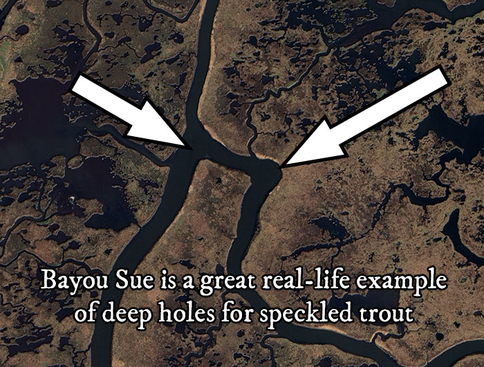
I would also drop waypoints on the larger bayous connecting the Mississippi River Gulf Outlet to Lake Borgne, a good way to find deep holes for speckled trout.
That’s because a lot of water on either side of these bayous have such a small space to flow through, and you can count on these bayous being deeper as a result.
Ultimately, you will have to launch the boat to go see for yourself, and that’s part of the process I personally use to find and catch fish.
Now, not all natural deep holes are this easy to find. Some aren’t as defined because the land around them has eroded away or sunk below the water’s surface.
A good example is Creole Gap in the East Biloxi Marsh. The land that was there caused water to flow faster through Creole Gap, making it deeper.
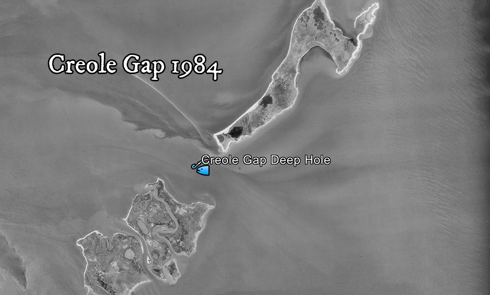
Being able to identify how water flows through the marsh and across the coast is critical to find deep holes for speckled trout.
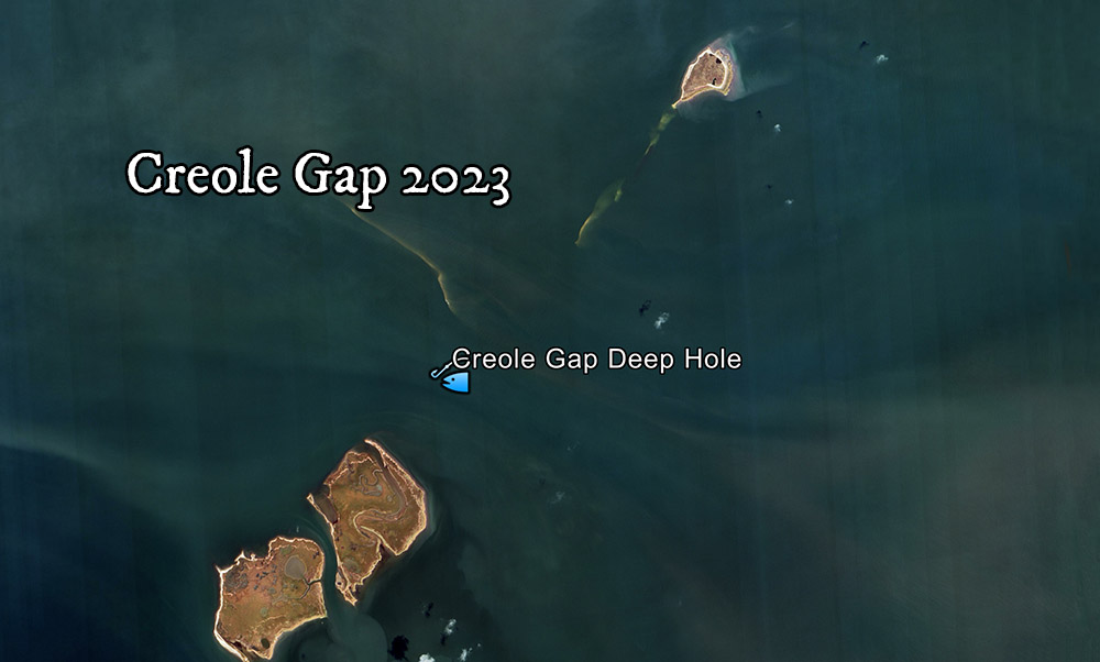
Is that deeper water still there? Yes, it is.
I know it is because I have been there and graphed it, but you can also see it reflected in Navionics’ Sonar Chart, another tool I like to use to find deep holes for speckled trout.
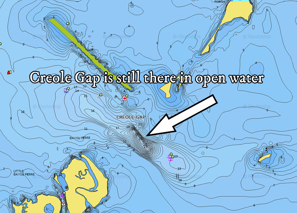
Another good example are the bayous in the sunken marsh of Empire. They’re not as easily detected, but they are still there.
Find Deep Holes For Speckled Trout w/ Navionics
Navionics Web App is a tool I use to look at community-sourced sonar data on their Sonar Chart product, and what you see in the screenshots above.
I use it on the desktop and their smartphone app.
Be advised, this product is not that reliable. You have to take it with a grain of salt. It’s not reliable because it is incomplete and some data is inaccurate.
After all, it is sourced from the community, not from professionals tasked with graphing these areas like you would see in a Lakemaster product.
So, Navionics Sonar Chart is, at best, a tool in the toolbox to find deep holes for speckled trout.
Learn Navionics Sonar Chart Easy
Navionics Sonar Chart is a good tool, but it can be confusing.
In fact, this is the case with many tools you can use for inshore fishing.
That's why I created a course called Fishing Trip Planning Resources & How To Use Them, where I detail all the tools you can use to locate biting fish and the best way to use them.
You won't find copy/pasted material from user manuals there.
That's because the course is built upon years of experience using those resources to successfully find and catch speckled trout and redfish.
But it does have its usefulness for inshore fishing, and that’s what you see here.
For example, at first glance, the pond of Geoghegan Canal on Google Earth Desktop doesn’t look 30 feet deep.
But if you looked at it on Navionics you would see the depth contours and realize that something is going on.
Then, after flipping through the historical time slider on GED, you would see that bottom detail is never apparent at any point in time, when it usually is for any other pond you would look at.
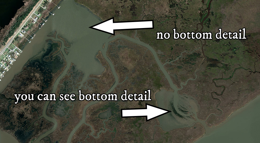
Knowledge Bomb: this same process can be applied to lesser known fishing spots that are just as productive.
And, if you can find them, then you’ll have one more honey hole you can rely on while everyone else is stuck fishing the same old spots.
So, now that you have an idea how to find deep holes for speckled trout, without even launching the boat, you may be thinking of ways you can replicate the same results with different tools.
Well, I’ve been doing this for a long time, and I think it’s worth mentioning what tools you should NOT use.
Tools I Do Not Recommend Using To Find Deep Holes For Speckled Trout
Like mentioned earlier, I strongly recommend not using Google Maps for inshore fishing. That’s because it only has one set of satellite imagery, whereas Google Earth Desktop has many more.
As a result, you have less information to make good decisions with.
For example, if you wanted to find deep holes to fish in Venice, then you may see these bayous connecting the Mississippi River to the marsh on the other side.
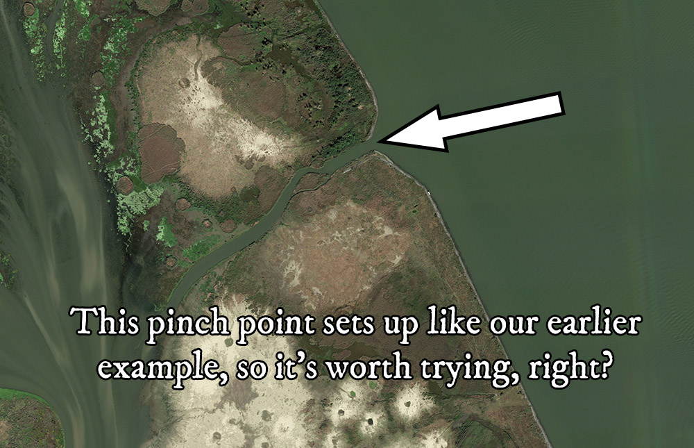
They could be good to fish, so you make a point to check them out.
But oh no! You rip off your lower unit because they’re actually filled with rocks.
Bummer, dude. If only there was someone who had been there and done that to explain the best way to avoid this….oh yeah, that’s me.
Because that’s exactly what I did in 2017.
At the time, Venice was fairly new to me and I had no idea that these relief canals dug by the Army Corps of Engineers were reinforced with rocks from top to bottom to prevent scouring.
The same kind of scouring we talked about earlier in this guide about how to find deep holes for speckled trout.
After a successful morning limiting out on redfish, I began exploring new-to-me places before donating part of my lower unit to the Mississippi River.
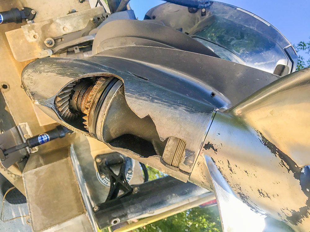
If I stuck with navigating and fishing places that I had checked out on Google Earth Desktop, then I would have avoided this tragedy.
You should do the same.
If you want more information on what happened, then I strongly suggest visiting this blog post I made about the incident.
Now, this does bring us to our next tool to NOT use to find deep holes for speckled trout: mapping chips.
And that’s for the same reason you wouldn’t use Google Maps: it’s only one set of imagery and it tends to be a dated set of imagery.
For example, if you used your mapping card — for your Lowrance, Garmin, Humminbird or whatever — to look for deep holes to fish on the south side of Lake Borgne (like we did earlier using GED) you may find this one bend in Grand Bayou that looks worth trying.
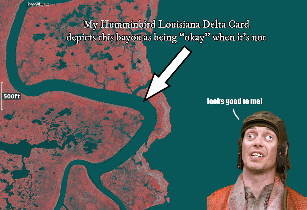
This is a screenshot from my Humminbird Helix 12 and it's Louisiana Delta card.
Now, that's just one mapping chip I run on my boat, what about the other one?
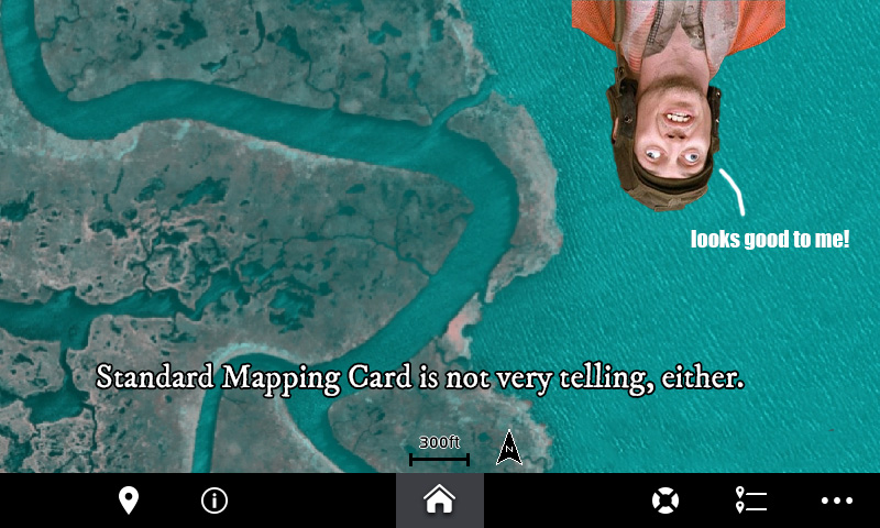
Screenshot from my Garmin GPSMap 742 and Standard Mapping E-Card
But oh no! You go there and get stuck and congratulations because you are now a SeaTow commercial.
Both of the mapping cards depicted above are excellent tools, but do not accurately (or safely) find deep holes for speckled trout.
If you think it's okay to navigate solely off a mapping chip, then you could be the guy saying "LoOkS gOoD tO mE!"
Do you want to spend your valuable time on water catching speckled trout, or do you want to spend it learning the hard way about navigational hazards, that you could have learned about the easy way on a computer in the comfort of your home?
Yeah, that’s what I thought.
So, that's why I recommend using Google Earth Desktop to locate fishing spots and safe routes, like in this video about why Delacroix is so shallow.
Because if you did that, then you would see that bend in Grand Bayou has long since silted in.
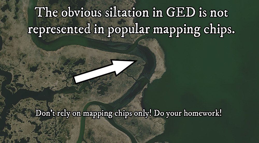
Putting It All Together
By now it’s pretty clear why you should use Google Earth Desktop and not rely solely on mapping chips, and really shouldn’t use Google Maps at all when you want to find deep holes for speckled trout.
Remember, Navionics is a good tool, too.
You should use these tools to identify about a dozen potentially good deep holes for speckled trout, then go out on the day of your fishing trip and fish them in person.
To learn how to do that the best way possible, I strongly suggest visiting this next guide about fishing deep water for speckled trout.
In it I explain how to approach them, what tackle to use and more so you are making casts where it counts and, above all, have fun catching fish.
Or You Can Get It All Right Now
You don't have to wait for me to publish a new guide here on Louisiana Fishing Blog. I am ready to teach you everything I know inside Inshore Fishing 101:
This course is only available inside LAFB Elite, where members have access to many other courses as well.
This video explains the benefits of joining this exclusive membership. I hope to see you inside!
Over To You
There's a lot we covered in this guide to find deep holes for speckled trout, so what do you think?
Chime in below in the comments section! I always look forward to see who's reading my content and what they have to say.
Sometimes I learn something new. You may as well, so always be sure to check out the comments.
Thanks for reading, and tight lines!

Hey Jerome, great question. That’s a good deal of what I teach inside Inshore Fishing 101, specifically, inside the Advanced Inshore Navigation Module:
https://www.lafbelite.com/course/inshore-fishing-101/
I’d say the majority of what I teach is finding biting fish from scratch then, after that, safely navigating the marsh. There’s a lot of hidden dangers out there and, over the years, I learned how to find most of them before launching the boat.
What I teach is a process that’s worked for me over many years ranging from the Mississippi Gulf Coast, to the Chandeleur Islands, to Venice, to Vermillion Bay and even Big Lake.
Devin, how do you navigate the biloxi marsh? GPS, experience?
As someone who has never been there how can I find my way around there?
Sure, if it freezes. But how often does it freeze in south Louisiana?
Devin, warm water does in fact sink and cold water rises.
Hey Jeff, I’m glad to see you like this article.
Very good news!
Okay, to answer your question…
Ya know, there are some good articles somewhere in here, but the really good stuff is inside LAFB Elite.
Since you’re a member, here’s a link: https://www.lafishblog.com/courses/sfms-part11-finding-the-best-redfish-spots/
You’re looking for the sections titled, “The Myth of Clean Water”, “Using Satellite Imagery to Find Awesome Redfish Ponds”, “Sorting Good Ponds From Bad” and “Identifying Consistently Clean Water”.
That should keep you busy for awhile. lol
Devin, I thoroughly enjoy your wisdom and knowledge as it relates to catching speckled trout. I’m trying to learn how to use Google Earth as well as you do, but it’s a slow process. Today, you really helped me understand about deep holes, even thought as you stated, the water color all looks the same.
One more comment if you do not mind. How can you find clear waters from Google Earth? If you mentioned this before, please accept my apologies.
Yes! Here’s the link: https://www.lafbelite.com/course/inshore-fishing-101/
You’re welcome, Francis! Thanks for being a regular, man!
Also, I like the bombshells on deep holes… tks
Devin, I may have missed it but did you break down how you planned your trip from 10/1/18? I enjoyed your fishing report and wanted to see how you did it, especially since that area is where I enjoy fishing.
Thank you!
Awesome very informative
Hey Robbie, I appreciate you commenting!
There’s a few places they’re biting at, but I only disclose that to members of LAFB Elite.
You can join here and see everything you get.
Thanks and tight lines!
Where’s the fish biting in Hopedale