Your mapping card categorically sucks and is probably the worst piece of equipment on your boat. I'll explain: one of the hardest things you can do when fishing Louisiana's coast is safely navigate to your fishing spot and back to the dock.
This is especially the case if you're not very familiar with a particular area. If you grew up fishing Lake Pontchartrain, then you may find the shallows of Delacroix somewhat intimidating.
So, most anglers meet this challenge by investing in a good GPS unit and accompanying satellite imagery on an aftermarket mapping card.
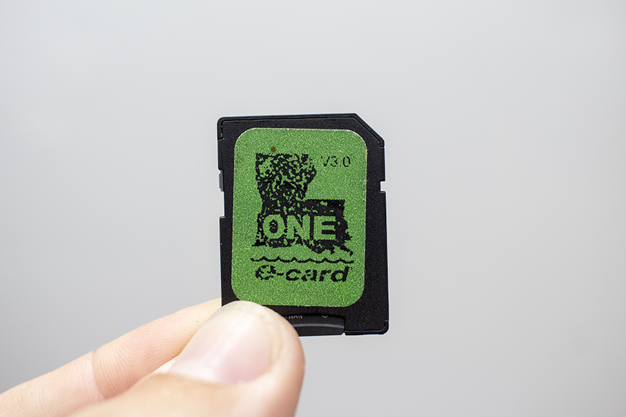
People just plug these things in and think they're good to go. Time proves them wrong.
In fact, mapping cards consisting of satellite imagery are often touted as the ultimate tool to navigating Louisiana's coast, and that's because Louisiana's marsh is so vast and complex that the conventional drawn maps of yesteryear don't offer the same level of detail one really needs to navigate the marsh.
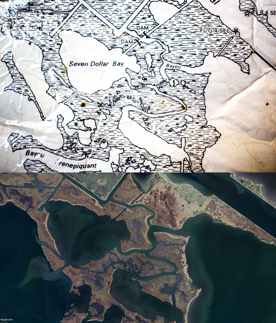
Modern satellite imagery reveals more detail like depth and presence of tidal highways.
So you can see the advantage of having detailed imagery in a mapping card like what you see above. You can see every nook and cranny of the marsh, whereas with a topographical map you are left without. The kind of tidal highways that pique angling interest are visible, as well as shaded areas that indicate shallower or deeper water.
Once you add the superior detail of satellite imagery with a GPS unit, you then have your current position plotted on it and — this is the icing on the navigational cake — breadcrumbs showing where you've been. *chef's kiss*
This is a very streamlined solution that's attractive to anyone wanting to navigate Louisiana's vast wetland. But there's a glaring problem with it:
It will f#&k your fishing trip and leave you stranded like a dumbass.
This navigation solution of GPS + mapping card has some glaring deficiencies that manufacturers don't want to tell you, or — even worse — aren't experienced enough to realize and, even if they do, don't know how to solve. They'd rather you look the other way and cross their fingers hoping nothing bad happens.
Well, not here and not now. In this guide I am going to:
- Take a giant, steaming sh*t on mapping chips.
- Expose their less-than-obvious flaws.
- Demonstrate a better alternative.
- Reveal what mapping chips are really best at.
In order to get started, we will establish why this is all a big deal in the first place:
Why is skillful navigation important in the first place?
Being able to skillfully navigate Louisiana's coast is important because you want to be able to get to your fishing spots then back to the dock with zero mishaps. So, if you can navigate the marsh at a basic level, then you can go on fishing trips to known areas without any mishaps, which is great.
But, if you can do this at an advanced level, then you can easily access new fishing spots via new routes. More opportunities open up to you and, by extension, you become a more competent angler who is able to catch more fish. That's a big difference! And some folks mistakenly believe a mapping card will do that for them.
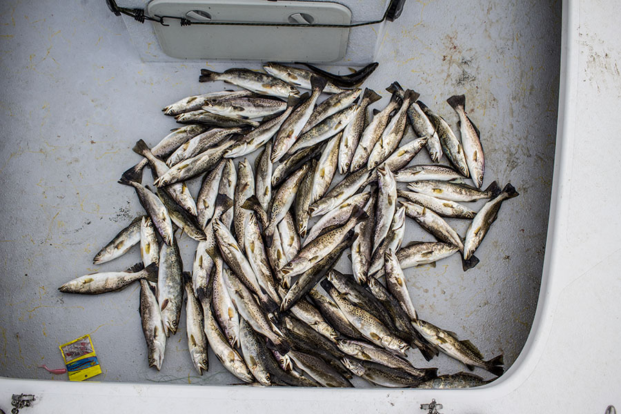
That's a lotta speckled trout.
Consider this example....
If you're only familiar with Biloxi Marsh because you've spent years learning it, then you would have to spend that same amount of time learning someplace new, like Delacroix.
Yes, you may be able to easily navigate Biloxi Marsh because you already know where all the hazards and safe routes are. But let's pretend that Biloxi Marsh has become devoid of fish for whatever reason but you hear that Delacroix is absolutely "on fire" with great fishing action. Well, you'd then be out of luck because you have no idea how to safely navigate Delacroix.
You would have to put in more years of time on water to accrue the experience needed to guide your boat across its waters, and that's a high cost. Not everyone is up for that challenge, so they'd rather stick with what they're comfortable with (in this case: Biloxi Marsh) even if it means not catching as much.
But, if you are skilled at navigating, you could figure out Delacroix in a much shorter amount of time and capitalize on the great action there. If you stick around and read this guide to completion, I'll show you how I do it (because I have and I do).
Surely by now you clearly see the incentive to being able to skillfully navigate Louisiana's marsh and beyond!
Navigating a new area is more complicated than it seems...
Running your boat in a "new to you" area is easier said than done! It's not as simple as knowing to "turn left here, then right, then another left and the fishing spot is on your right".
If it were that simple there would not be as many boating mishaps as there are. That's because — in Louisiana — it's easy to run aground or strike an underwater hazard, bringing your fishing trip to a grinding halt, or worse. It happens all the time.
This begs the question: why is Louisiana's marsh so difficult to navigate to begin with? Let's explore that next.
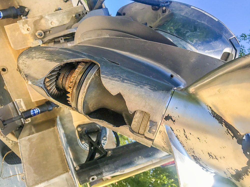
Whenever I had an accident like this one, it was because I wasn't using what's taught in this guide.
Louisiana's Coast is a Navigational Challenge (and the reasons why)
Now, before we jump into this, it needs to be made clear that I understand every coastal area on the Gulf Coast and beyond has its navigational challenges.
In fact, I'd say that we have it pretty easy in Louisiana with the relatively weak and forgiving tide that flows here. That certainly makes life easier than say, places with a tide fourteen feet high.
But this doesn't mean that Louisiana doesn't boast a slew of other navigational challenges to overcome. These include, but are not limited to:
Especially dredge operations. You don't want to hit a submerged dredge pipe. Now that you're warm and fuzzy, let's take a closer look at these in detail:
Your Mapping Card is Missing Marsh Wrack, Coastal Erosion & Subsidence Of The Land
Parts of Louisiana's coast are continually disappearing, with some places disappearing faster than others. The chief culprits are erosion, subsidence and storm damage.
These three forces work together (or independently) to remove marsh from Louisiana's coast, replacing it with open water. But the problem is that this open water is not safely navigable for your boat in the same way a pre-existing body of water such as a lagoon or bayou would be. It looks like it is, but it's not.
Marsh Wrack
The marsh in Delacroix is a great example of this, as the top layer of grass was peeled away by Hurricane Katrina, leaving only shallow water in its place. This thick carpet of marsh was then deposited elsewhere, either filling in other parts of marsh are sinking somewhere else altogether.
The $10 word for this thick carpet of displaced marsh is called "marsh wrack", and we saw a bunch of it after Hurricane Katrina in Delacroix in 2005 and in the Lafitte area after Hurricane Ida in 2021.
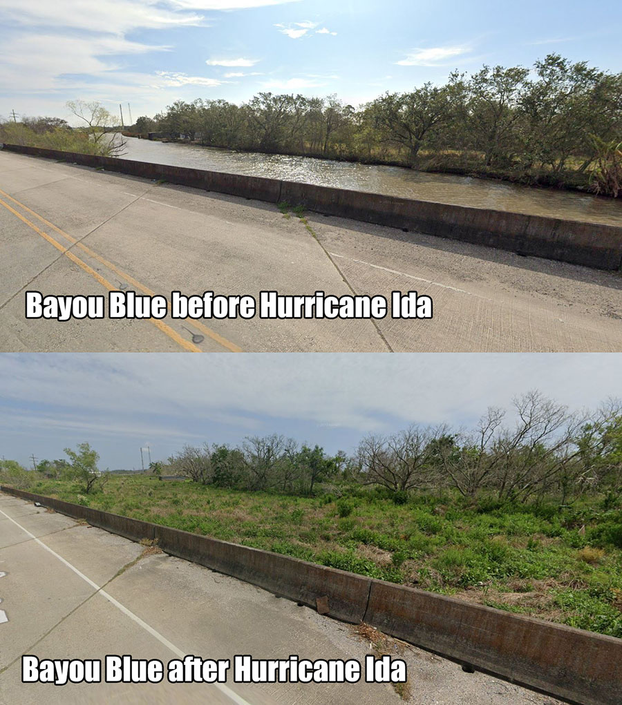
Marsh wrack filled Bayou Blue in Pointe aux Chenes after Hurricane Ida in 2021. For a long time it was not navigable to boats.
Erosion of the Marsh
After that is routine, every-day erosion of the marsh. Places that have the most water flow tend to erode the fastest. It's a slow burn: as the tide comes and goes it takes a little land with it and, if that land is not replaced, it disappears beneath the waves.
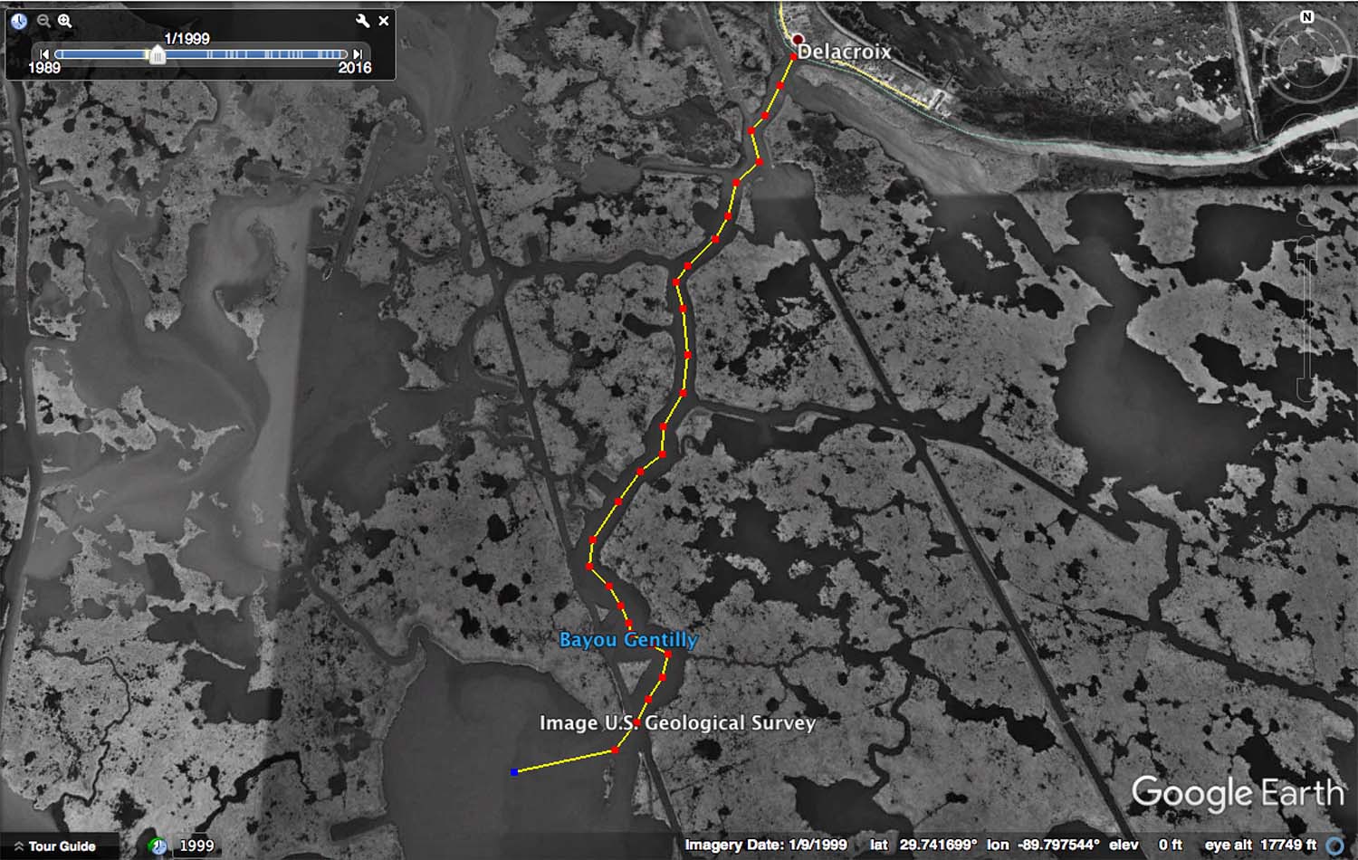
Bayou Gentilly before Hurricane Katrina
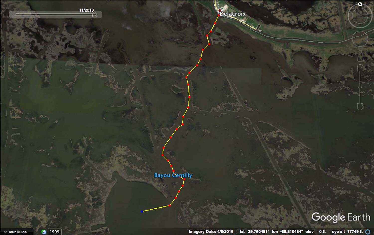
Bayou Gentilly after Hurricane Katrina
The above example in Delacroix is a good one. You can see how Hurricane Katrina eroded away the shoreline of Bayou Gentilly, making it very difficult for inshore anglers to know if they are in the channel or not. Many boaters have become stuck out here, especially at low tide.
It's worth noting that this erosion was sped up by Hurricane Katrina, but places like Grand Pass in Dularge and the mouth of Bayou Biloxi at Lake Borgne are examples of everyday erosion taking its toll over decades.
Subsidence of the Land
Some places on Louisiana's coast have already disappeared, and not totally due to the two aforementioned forces. Some have sunk below the water line and Empire is a great example of this.
If you look at older paper maps of the area, you will see clear outlines of bodies of water, but when compared to newer satellite imagery those outlines are gone. Now it's a guessing game of where the navigable water is hiding amongst the hazardous shallows when running solely on a mapping card.
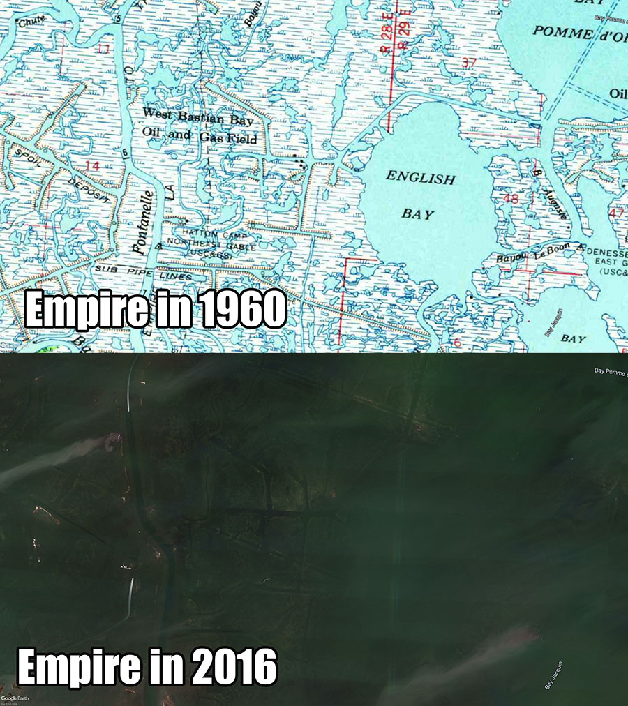
Clear water and satellite imagery reveal the canals and bayous that used to be there.
Mississippi River and Coastal Restoration are not depicted on your mapping card...
Next up is all the new land that was built and is currently being built across Louisiana's coast.
The two major drivers behind new land are the Mississippi River and the Coastal Protection and Restoration Authority, the organization tasked with preserving and building back Louisiana's coast.
Yes, a lot of new land has been made, especially with the high river we had during the Freshening. You can go see it in your boat, either on purpose or by accident when relying solely on a mapping card. Ask me how I know ;)
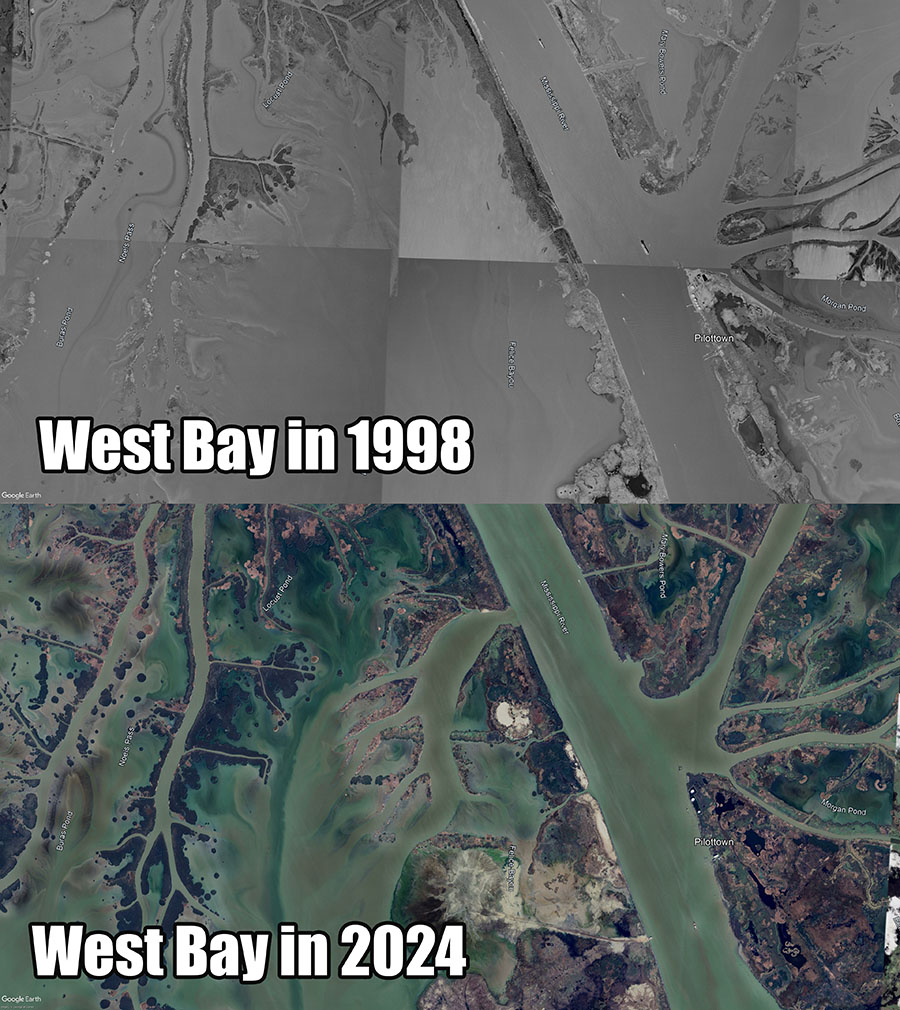
The above graphic makes it obvious that this is a problem just like one posed by erosion and subsidence, just in reverse.
An Important Note About Encountering New Land With The Hull of Your Boat
The new land built from siltation by the Mississippi River is not soft and forgiving like what we see in older marsh, like Cocodrie or Hopedale.
No, it's hard and unmoving and running aground on it is like running your boat onto a concrete driveway. The stuff is basically powdered lead and is an absolute nightmare to get out of.
You're better off using what I teach in this guide to avoid the headache in the first place!
Underwater Hazards
Without making this article any longer than what it needs to be, I can accurately (but briefly) state that there's just a plethora of ungodly underwater hazards — most of which are man-made — just waiting to ruin your lower unit or worse:
None of these are seen by mapping cards because they lack the detail necessary to see these things and, even if they did, are you really going to notice these hazards on the fly? That's not realistic or practical. Sure, some are marked by white poles, but even those are confusing.
It's better to plan ahead, as I'll reveal later in this guide. But for now...
Yeah, Louisiana's coast is a train wreck...
Now it's obvious that Louisiana's coast is a total sh*t show and there's a lot that can go wrong if you're not careful. Some places are worse than others. For example, the Biloxi Marsh is pretty static and hasn't changed much in the big scheme of things. But anywhere near the Mississippi River has proven challenging with the continual shifting between erosion and new land being built.
And this reveals the big problem with any mapping card...
The problem with mapping chips is that they are not complete. They do not show you everything, especially dangerous navigational hazards. In fact, I'd venture to say that it's nearly impossible to show every single instance of something that could be harmful to your boat. This is due to a few reasons:
First, Louisiana's marsh is vast. It's a lot of shoreline, structure and navigational hazards to catalog and put on a map.
Secondly, the low-grade imagery on mapping cards only contain information for what's at the water's surface and above it. It doesn't tell you much about what's under the water.
Reservoirs on the Tennessee River are a good example of knowing what's underwater. The topography for these lakes was well defined before they were flooded, and today there are people who have completely graphed those bodies of water with precision sonar to create detailed sonar maps showing exactly where shallow and deep water is.
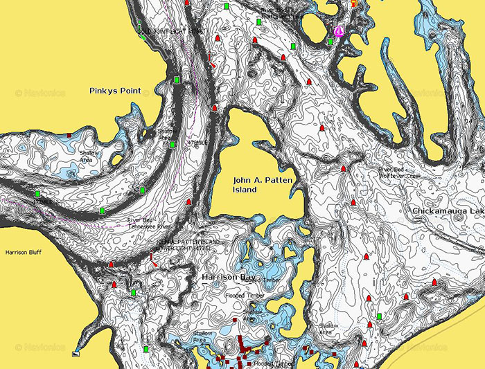
This is not practical to do in Louisiana and, even if someone did, their work would be quickly erased because Louisiana's coast is always changing.
Some areas get choked out by vegetation, other areas silt in and turn into land. Some places are completely wiped out by hurricanes, and other areas are choked out by marsh wrack resultant from those storms. This is everything we covered above.
Lastly, there's only one set of imagery on your mapping card. That imagery is most likely already dated, being at three to five years old. All of the above things we talked about have happened in that time, rendering your precious (and expensive) mapping chip obsolete.
Given the trend of how mapping chips have been produced and distributed over the last 10+ years, it is unlikely that mapping companies can keep up with the rate of change on a scale as large as Louisiana's coast and do so at a profit.
I just haven't seen it. That and they're all doing the same thing: taking generic imagery from another company, putting it on an SD card with their logo and *voila*! A $500 product!
But the worst thing about mapping chips isn't what they lack, it's what they lead you to believe:
The Very Worst Thing About Mapping Cards Is...
Not only do they fail to show you the navigational hazard, they invite you to believe that the hazard you're looking at is safe.
This is a giant problem.
Three Examples of How Much Your Mapping Card Fails At Life:
So it's obvious that mapping cards do not capture these changes as efficiently as they're touted to, nor do they give you anything to identify them.
But — because I know there are going to be room temperature IQ's screaming bUt muH mahpPiN cArD iS gUd!! — let me make some real-life examples (that are literally coming off the top of my head) to state my case.
Below you will find actual hazards that have gotten me (or someone I know) and then show you how much they are not on the mapping cards that are so beloved by the ignorant masses:
Case #1: Army Corps of Engineers Rocks in Venice
This one is an oldie, but a goodie. If you look at the west bank of the Mississippi River on either side of the West Bay cut (north and south), you will see what appears to be a total of four canals or bayous that flow from the river into the surrounding waterways.
At first glance, these seem innocent enough and appear to be like any other navigable body of water. Even in person they don't seem out of the ordinary.
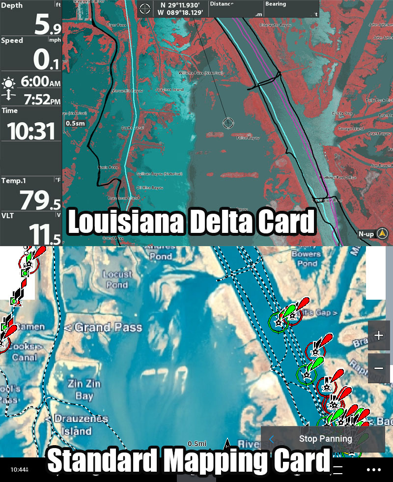
As you can see, these appear to be like any canal or bayou you'd use to navigate your boat. But they're not. They are not like any other navigable body of water because they are filled with rocks to just below the water's surface. These things were practically designed to kill lower units.
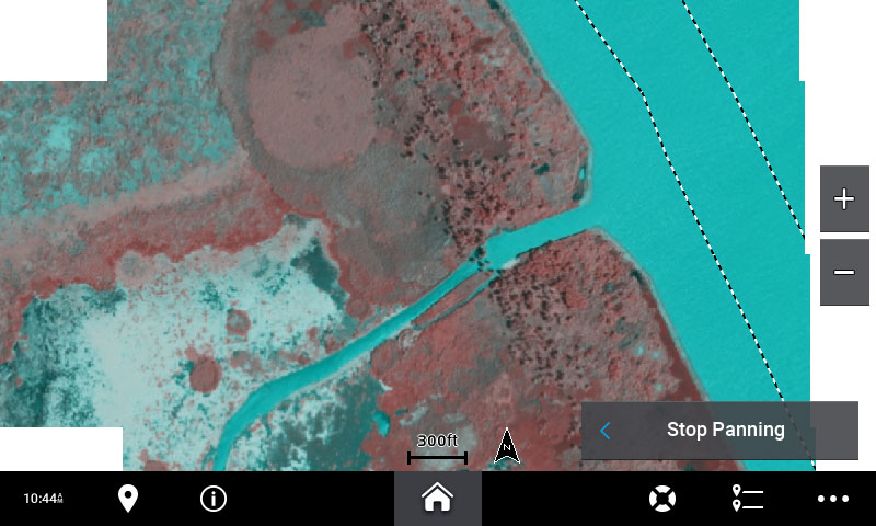
Nor are they marked. There are no signs, nothing to indicate to anyone without extensive local knowledge that they should find another way. If you'd like to learn more about these, why they were made and how one got me back in 2017, then please check out this blog post.
And yes, even when you zoom in on the offending canals, there is nothing to denote the rocks there that will destroy your boat, like what you see below.
Case #2: Pointe Aux Chenes Pipeline
Go to this marsh near Pointe Aux Chenes and you'll see that the pipelines and rocks that nuked my buddy's lower unit (while I was in the boat with him) aren't visible or marked on the following mapping cards:
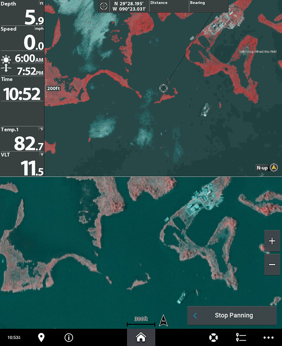
The crosshair on the top image is where the hazard is at. There's no way to see it, nor is it denoted in either card. This is dangerous because you're led to believe it's open water safe to navigate!
That accident made for a tough day on the water, but we still caught fish and arrived home safely. To get the full story, visit this blog post here.
Case #3: Bay Long in Pointe a la Hache
In 2020 I was out sight fishing redfish in Pointe a la Hache and enjoyed a successful day. Once it was time to head in, I wanted to take Bayou Fucich to where I launched at Beshel's Marina.
This was a giant mistake, as that bayou is directly in the outfall of the Mississippi River which, during the Freshening, dumped a lot of land-building sediment into the surrounding waterways.
So I took a body of water that appeared navigable on both of my mapping cards, a body of water named "Bay Long". Well, let's call it "Bay Short", because it's a little short in depth these days! Yep, you guessed it, I grounded my boat in ankle-deep water at full speed.
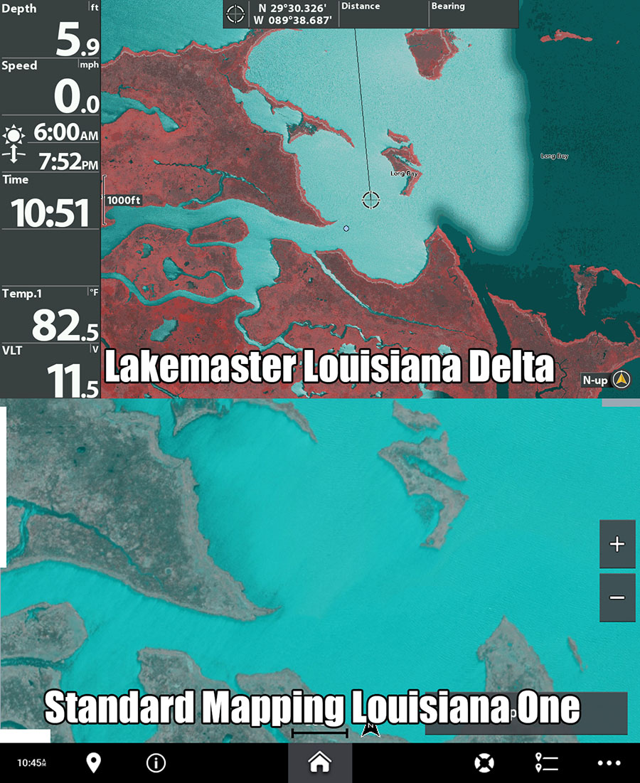
I needed an airboat to get me out and, fun fact, the airboat almost got stuck trying to get to me! You can watch this entire drama unfold in this YouTube video.
But These Examples Are From Older Cards
But these are on old cards from 2010 and 2014, so if you have a newer card then consider checking the above examples on them and, if you're feeling charitable, let us know about it in the comments section below. Thank you!
And I can go and on. I literally came up with these off the top of my head because I spend an inordinate amount of time staring at satellite imagery and actually fishing across Louisiana's coast.
Not talking to people who do it (like journalists do), not fishing with a buddy (like 99.99% of YouTubers do), not taking it easy and fishing community holes that are easy to reach (like most anglers do).
Nope! I'm launching the boat and making 100+ mile round trips in search of speckled trout, redfish, triple tail and more. This is putting in time on water in its purest form and I've done it in spades. That's how I know!
While most people only fish a single area in Louisiana their whole life, I have fished just about all of them and, when I did, I did not go under the tutelage of a fishing guide or friend who knows the area.
Nope! I did my navigational homework then rolled out. And I am telling you, the only time I've had issues is when I did not do that homework or strayed from the safe routes that homework uncovered.
So it's clear that mapping cards are not an ultimate solution. Not even close.
So what is the ultimate solution over a mapping card?
Well, I've navigated Louisiana's coast from Slidell to Venice to Vermillion Bay to Big Lake in everything from a flatboat to a bass boat, to a bay boat, to an airboat.
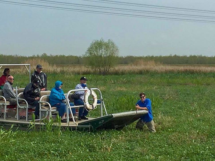
Yeah, I got an airboat full of Yankees stuck. Top that.
I've had my share of mishaps along the way and years of experience have revealed what works best for safely navigating Louisiana's coast:
The absolute best way to navigate the marsh is by carefully researching the area you want to fish using Google Earth Desktop.
No, not the app on your smartphone. No, not the web-based version. I mean the program you use on a desktop or laptop computer.
Also known as Google Earth Pro, Google Earth Desktop (or just GED for short) is an incredible mapping tool that is far more powerful than your $500 mapping card.
Remember those earlier examples? GED handles them!
Yeah, all those navigational hazards I covered earlier — the ones that were completely overlooked by the high-and-mighty, wallet-lightening mapping cards — are all easily detected on totally free Google Earth Desktop:
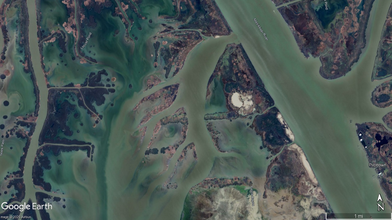
Case #1: Army Corps of Engineers Rocks in Venice
Click to Enlarge
You can very easily see the siltation of West Bay in the above image from 2024. It gives you a much better idea as where navigable water is and is not. Additionally, Google Earth Desktop will continue to do so in the years to come (just as it has since I first started using it in the 2000s). But what about those rock-laden canals?
Click to Enlarge
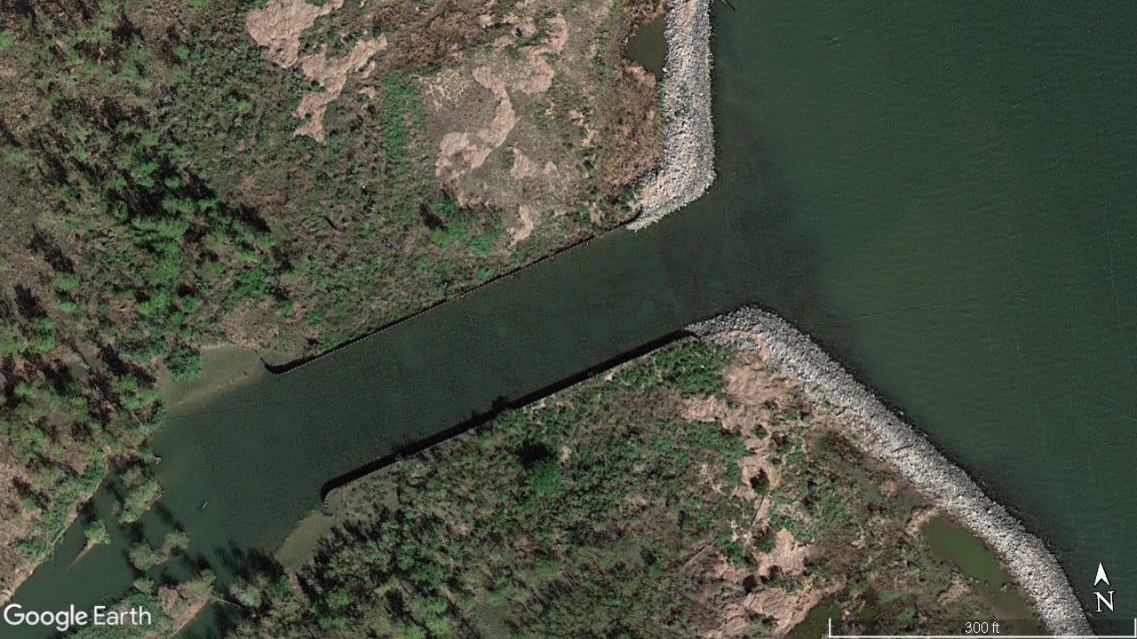
What you see above is something screwy. Anytime you see shading like that, then that means funny business is going on and warrants either avoiding or, at the bare minimum, slowing down to a stop and taking a look before proceeding. If you did, you'd see the rocks and know to find another way (if you're a smart inshore angler, you'd already have a secondary route selected just in this event).
Case #2: Pointe Aux Chenes Pipeline
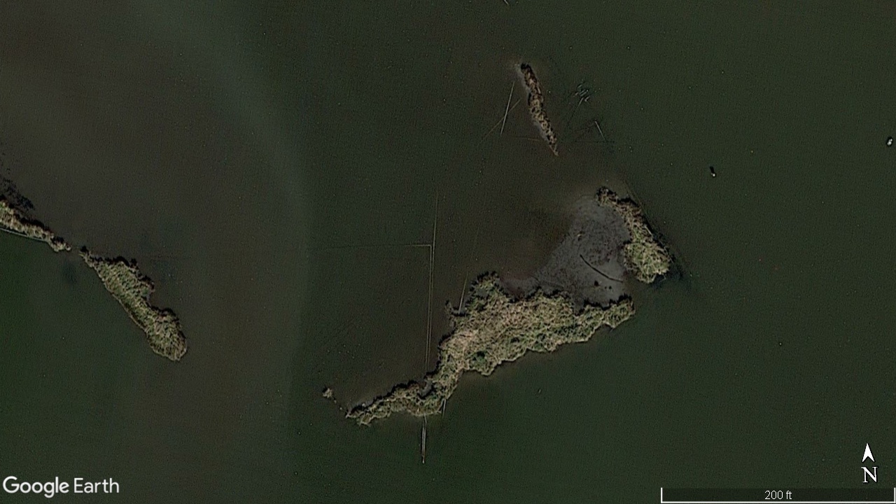
Look below and you'll clearly see the oilfield pipelines sticking out of the water on a day the tide was low.
Click to Enlarge
Again, scroll up to compare the above image with the images from Humminbird's Lakemaster Louisiana Delta card and Standard Mapping's Louisiana One card. Not only do they not depict this level of detail, but they also fail to mark what's otherwise an easily recognizable hazard (when using what I'm teaching you here).
Case #3: Bay Long in Pointe a la Hache
What about the spot where I got hard-stuck in Bay Long? We get the same result with Google Earth Desktop:
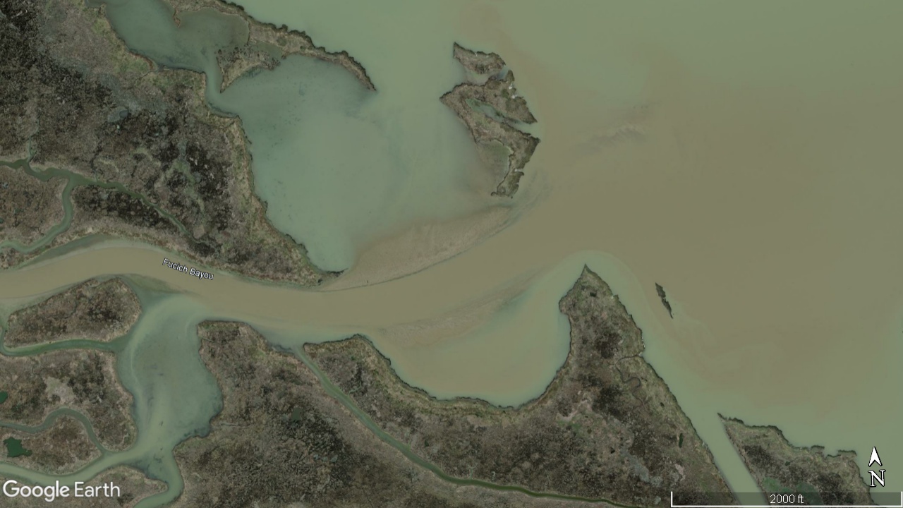
Click to Enlarge
Here you can see the obvious siltation on either side of what is now Bayou Fucich extending out into the bay. If you can see that new land at low tide (which is when this picture was taken) then you will certainly run aground in the shallow water above it when the tide is high.
How is a free computer program so much more powerful than an expensive mapping card?
It's more powerful because it gives you multiple sets of imagery that reveal trends, navigable water, places you'd like to fish and underwater hazards you'd want to avoid.
It can give you context that a mapping card does not, that all-important context that tells you if a particular body of water is more likely to be dangerous or to be safe.
But there's more! You can also use waypoints and tracks inside GED that can be uploaded to your boat's GPS for use on the day of your fishing trip. You would literally be following a breadcrumb trail you created that you know (or are far more reasonably certain) is safe to navigate.
The idea here is that before I fish an area, I give it a hard look on GED to locate good fishing spots, identify safe routes that lead me from the dock, to them and safely back to the dock, and detect any hazards to navigation along the way and mark them so I can avoid them.
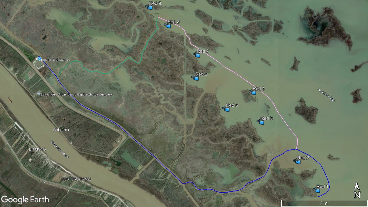
This is proper fishing trip planning! Click to Enlarge
How exactly do you accomplish this?
Now, I could write a book about using GED in conjunction with your fishing trips and, lucky for you, I did.
It's titled Boot State Specks, and you can find everything I know about safely navigating Louisiana's coast in chapter five, Advanced Inshore Navigation.
However, you should know that this book is also available in the form of a video course titled Inshore Fishing 101. What you can learn there is far more valuable than any mapping card by itself, as the course is 12 hours of detailed video lessons revealing everything I know about finding and catching speckled trout right here on Louisiana's coast.
But here's a quick example for your own education, here and now:
Learn from this example at Bayou Gentilly in Delacroix:
In the aftermath of Hurricane Katrina, the marsh on either side of Bayou Gentilly was largely destroyed.
This was a problem for anglers because they could no longer see where the edge of the bayou lay. Straying over this boundary — especially when the water was low — could result in a grounding or worse.
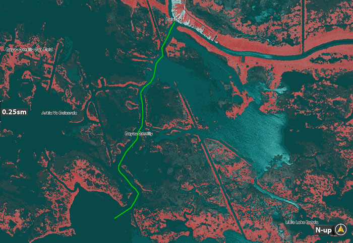
For your reference, here are aerial photos of Bayou Gentilly before and after Hurricane Katrina:
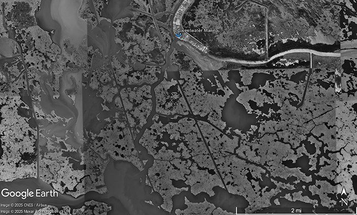
Bayou Gentilly before Katrina in 1999
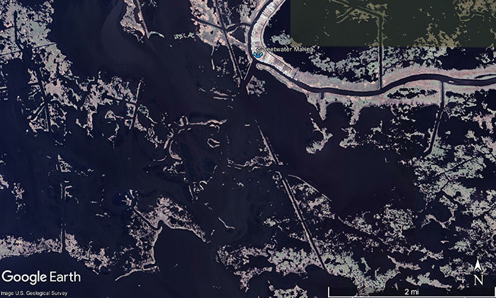
Bayou Gentilly well after Katrina in 2024
So you can see the navigational challenge of launching from Sweetwater Marina (marked with the blue anchor) to go fish nearby Little Lake (just left of the bottom middle of the picture). What used to be a pretty straightforward boat ride is now a navigational nightmare.
But it's easily solved using Google Earth Desktop, because you can use the old imagery to see the edge of Bayou Gentilly and lay in a safe route based on that information.
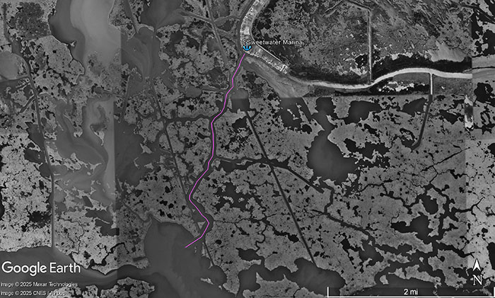
Now that the route is made, you can flip to post-Katrina imagery and see how it safely leads through the confusion of what's deep or shallow. The navigational nightmare is solved!

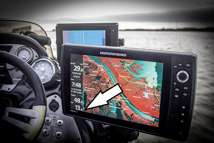
All you need to do next is upload that route to your GPS for use on the day of your fishing trip, like what you see on my Humminbird Helix 12 below:
If I didn't have that route, then I'd have no idea where the channel would be and would risk running aground. But now I do! That's one way I safely navigate areas that are new to me and end up catching a mess of fish, despite having never been there before.
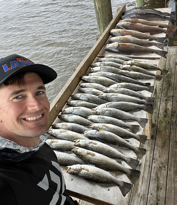
My buddy and I caught a limit of trout and some redfish using what I teach inside Inshore Fishing 101. Let me show you how!
In fact, for years I didn't use a mapping card on my GPS. All I used was tracks and waypoints made on GED then uploaded to my boat's GPS.
This worked well, and I could make a good argument that a mapping chip loaded with satellite imagery isn't worth the money if you know how to use the GPS's pre-loaded maps in conjunction with Google Earth Desktop. But I don't. I use several mapping chips.
Which leads us to our next question: what do I actually use a mapping chip for?
What Mapping Cards Are Really Best Used For When Inshore Fishing In Louisiana
Well, I use it for situational awareness or to take advantage of unplanned opportunities.
For example, I may decide that I want to change gears in the middle of my fishing trip and go from fishing speckled trout to fishing for redfish, and a quick look at my mapping chip reveals a good looking pond that's just around the corner.
Or, in the event there's a storm that blows me off course, I can use my mapping card to navigate an alternate route around it, safely back to the dock.
Yes, there are risks associated with this, but it's an acceptable level of risk that's worth the circumstances.
That and if you've done a map study of the area using GED, you'll have more information to work with than if you had not and relied solely on the mapping chip instead.
That's Why Using An Older Card Is Just Fine
As long as you do your GED homework you will be fine using an older card. The older card gives you additional on-the-fly context that, used in conjunction with the waypoints and tracks imported from GED, makes you that much better at navigating Louisiana's coast.
The only time I have problems is when I start going off-route and navigate only by mapping card. That's asking for trouble!
Otherwise, there's no real advantage to buying an "updated" card. The updated imagery you want is already available for free on the Internet. Use your head, not your wallet.
As you can see, I use two mapping cards at once on my fishing trips. They are a means to an end, not the end itself, and I would not dream of navigating a new area without doing my GED homework first.
Where You Can Learn More Inshore Navigational Goodness
Hopefully by now you've been armed with a good deal on navigational knowledge that will empower your fishing trips.
Perhaps you learned something that you did not know you didn't know and, if that's the case, I'd like to take a moment to point out that there's most likely additional information you don't have at your disposal. I'd like to fix that.
That's why I created Inshore Fishing 101. It's the foundational knowledge detailing how to plan successful fishing trips from scratch, teaching willing anglers everything from finding their own fishing spots based upon the conditions to safely navigating to those spots and back to the dock.
This course is only available inside my membership LAFB Elite, where anglers get access to the rest of my courses as well as the LAFB Elite Community to talk fishing with members, plan their fishing trips and read the latest fishing reports.
Walker Porter
Easy To Follow Along
I love that Captain Devin puts himself in my shoes as an amateur fisherman.
This ensures great clarity and keeps me from having to go look up something to try to figure out what he is talking about.
Inshore Fishing 101 dives into detail for everything you need to know, but that course combined with the LAFB Elite Community is the best tool you can use to quickly shorten your learning curve.
One way members do this is by asking others for feedback on an area or for safe routes they've created. This is a big deal, because most people in the realm of inshore fishing have no clue what Google Earth Desktop is, much less how to use it to safely navigate an area.
There's more than just Inshore Fishing 101, there's also Inshore Fishing 201, Sight Fishing Mastery School and the seasonal courses for fall, winter, spring and summer, as well as all of my seminar recordings.
Conclusion
What you use for your fishing trips ultimately depends on you and your needs.
If you always fish the same area and get to know it very well, then you probably don't need much in the way of GPS units and mapping cards.
Me, personally, I do. And that's because I spend a lot of time fishing areas that I am new to or haven't memorized yet. I don't just fish one area, I fish all over. In the last year I've fished Delacroix, Shell Beach, Hopedale, Breton Sound, Mississippi Sound, Pass Christian, East Biloxi Marsh, Lake Pontchartrain (the entire thing), Buras, Pointe a la Hache, Empire, Venice, Grand Isle, Port Fourchon, Lake Boudreaux, Cocodrie, and Lake Salvador and have not had a single accident.
And that experience has taught me that mapping cards are not the best solution by themselves. The best solution to navigating Louisiana's coast is doing your homework on GED and combining what you discover there with the utility of the GPS and your choice of mapping card.
What do you think? How do you navigate the marsh? What about areas that are brand new? Chime in below!

Hey John, thanks for commenting. Not too many people take time to do that, so I appreciate that.
Yeah, the navigational knowledge I teach (which includes my scathing criticism of mapping cards) has not kept anglers at home, but put more anglers in the fishing spots they want to be in, and safely. Because of me, at least hundreds more anglers (a conservative estimate, seeing that about 5,000 have taken my courses) have the confidence required to go into new-to-them waters and catch limits of speckled trout and redfish.
Here’s an excerpt from a fishing report this week where a member of LAFB Elite caught his limit of speckled trout out of Hopedale. He was relating how much he has grown as an inshore angler:
“I left after about 4hrs and went home skunked and frustrated, lol. This particular trip however, is how I discovered LAFB. I went home and YouTubed ‘How to catch Speckled Trout in Louisiana’ and saw your ’30 Minute LAFB Commercial’ and became a member that day.
Since then, I got rid of the Go-Devil, bought a new boat, completed Inshore 101, and now have caught my limit of speckled trout in Cocodrie, Venice, Delacroix, Breton Sound, and Hopedale. A few honorable mentions just because I came close to catching my limit but came up short are Port Sulphur, Grand Isle, Lake P, and Lake B.”
I agree with you: the cards are not completely useless, for the reasons mentioned in the article above. But to rely on them, or spend more than $100-$200 on them, or to believe how they’re marketed, that they’re anything more than a very basic aid to navigation, is to meander from a result other than what my member posted above.
Yes, Google Earth Desktop and using a computer (it’s 2025) requires a little technical acumen, but that’s good because it gets the #1 thing any of us have firing on all eight cylinders to make a good fishing trip: our brains.
The best thing you can do is think critically about your fishing trip, where you’ve been, where you are, where you’re going.
Lastly, I 100% agree with you: if you’re not sure about an area, just go slow. I like to use sonar to see what’s on the bottom, how deep it is, etc.
Thanks for visiting and taking to comment, John. I really appreciate that.
Devin-
Great article. Overarching, I agree with the principles you outline. For anyone NEW to the LA Bayou structure and marshes, simply getting “LOST” is very easy and likely inevitable due to the same looking marsh topography for miles and miles post hurricanes. I have run the standard mapping safe routes for a few years now with the LA One chip and 99% in the particularly vast Delacroix area to help me get familiar with the main bayous and learn key landmarks. The risk is 100% absolutely when one decides to explore off the “safe routes”. So, going with someone more experienced is valuable and if alone, yes GED techniques you teach can provide some more insights. So, to infer the cards are useless coupled with some that may be computer challenged could discourage one from leaving the dock and miss the beauty of the marshes (not to mention some great fishing). I think there is a balance of respecting what the cards are designed for and when they are irrelevant due to the shifting marsh structure. Again, you offer insights from experience and highlight other valuable tools to make your fishing experience a good one. Appreciate the article… PS – yes, I have been “lost” in the marsh and idling slowing and reading the shorelines and current flow got me back to the yellow line:). Tight Lines…….
Hey Robert, thanks for asking. Great question.
The answer is not straightforward at all, because there are umpteen different makes and models of marine GPS out there and, unfortunately, they all use proprietary formats, probably in a lame effort to corner the market. So Lowrance uses .usr and Humminbird takes it a step further by using .ht and .hwr that’s only configurable through a program that’s only available for desktop PCs. It’s maddening. Fortunately, everyone else is pretty much drag and drop onto an SD card then upload from there.
Since Google Earth Desktop uses .kml you will need to convert files. I use GPS Babel for that.
That Humminbird program is called Humminbird PC, and I do have a course on that. It is a good tool, I’ll give it that. It’s only needed for Humminbird Helix models. Solix uses drag and drop .gpx files (as does most Garmins) and those are much easier to work with. Inside Inshore Fishing 101 I have instructions for Simrad/Lowrance that works for most anglers since that is what most anglers on Louisiana’s coast use.
Either way, for the reasons described in this article, learning this knowledge and practically applying are 100% worth the effort, especially on the game-day of your fishing trip.
I do not have a course for every single make/model of GPS, that’s why I created the LAFB Elite Community, so folks can get help from not just myself but other like-minded anglers who have the same GPS as them and have already figured out how to transfer tracks and waypoints.
Thanks for posting a comment, Robert. I hope that answers your question.
Hi Devin, Great article! My question is how exactly do you upload GED information and tracks onto your boat graph? Also, con you overlay it onto your mapping card somehow?
Perhaps I need to join your membership program to get this information? Regards, Robert Redfish
Please leave a comment to let me know you were here. If you have anything to add, or simply a relatable experience, then it’d be great to have it here. Tight lines, and thanks for visiting!