You'll know it's all a ploy as soon as you lay eyes on this old map of Hopedale. The worst part? People still use it today to decide where you can and cannot fish!
More...
Some people are hopeless history nerds that must know how things came to be (yup, that's me....guilty as charged)
One of those weaknesses are naming conventions.
For example, we all know how the Spoil Canal got its name, because that is where all the spoil was put during the construction of the Mississippi River Gulf Outlet.
There are more obscure, but far more tantalizing, points of interest such as Brady Lagoon, Bay Eloi, Dead Duck Pass and more. How did they get their names?
Need help finding a body of water?
Louisiana is home to over 19,000 square miles of wetland, and thousands of bayous, lagoons, lakes, bays, ponds and more.
So how do you find them from scratch?
This blog post details how to find virtually any body of water on Louisiana's coast.
I usually turn to the Internet for these answers and will do hours of deep digging to satiate my curiosity.
After all, the people who were there before me aren't my ancestors, but they are certainly my predecessors and we have much in common.
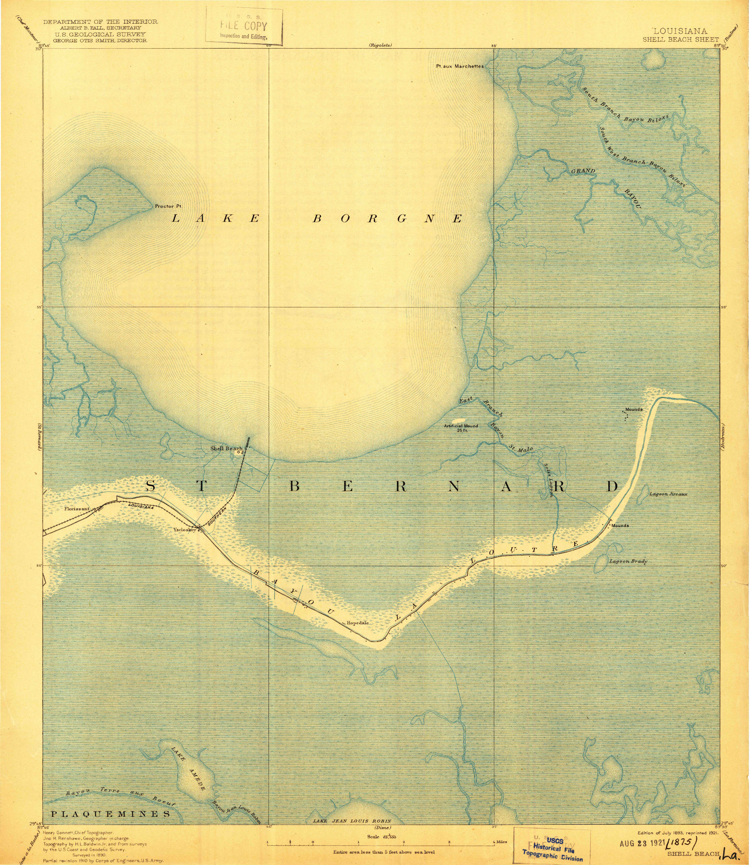
It was in one of my forays into history that I came across an old map of Shell Beach and Hopedale. It was drawn in 1893 and I can only imagine what the area looked like then, before the construction of the MRGO and logging of virgin cypress forests.
Anyways, take a look below at this old map of Hopedale. You will have to click on the map to enlarge it.

Old map of Hopedale, Louisiana from 1893
This exact old map of Hopedale wasn't used in 1812 when the United States made the Louisiana Purchase, because it wasn't even made yet!
But it's safe to assume that a map 81 years older would not have a whole lot more detail.
How is this old map of Hopedale important?
Property rights were assigned based upon a map very similar to this one. This map fails to show 99% of the various bayous, lagoons, bays, etc. that make up the Louisiana marsh.
So land owners are using this technicality to insert their property rights over bodies of water that have naturally existed for hundreds, if not thousands, of years before 1812.
This flies in the face of the Public Trust Doctrine, but they have been doing it anyway.
By the way...
...when I say "land owner", I am really referring to "oil companies" as they are the lead instigators in this issue. They set the bad example and others follow their cue.
It is scary how much is left out when you consider people make decisions based off that old map of Hopedale
For anyone in the 21st century to take advantage of that is kind of dishonest.
After all, how many mapmakers were around in the 1800s with enough pencils, paper and patience to document every single body of water?
What This Means For You
Bodies of water that should be open to me and you to go fishing in are not.
There are people blocking them off for their own greed, to keep those lagoons and ponds for themselves or, even worse, charge you a hefty fee to fish it.
This wouldn't be allowed anywhere else in the United States, but it's happening here in Louisiana.
How You Can Help
You aren't powerless to prevent the loss of water access, join myself and other concerned citizens at the Louisiana Sportsmen's Coalition.

They are the only grassroots organization fighting for your fishing freedom!