The Spoil Canal is the fastest route to get on some specks, but is practically designed to create boating accidents. Here's how to safely run the Spoil Canal and return home without a scratch.
Get Straight To The Good Stuff
Note: If you just want to see how to run the Spoil Canal (and get a tour of every turn), watch the video below and download the GPS tracks for it here.
But, if you want to learn more (and get extra goodies) keep on reading.
Spoil Canal 411
Veteran inshore anglers possess an intimate understanding of the marsh because they know how everything came to be in the first place.
This is how they consistently find fish, know which lures to use and -- not as obvious, but still important -- safely navigate the marsh with confidence.
You should have this confidence, too! So let's go over everything about the Spoil Canal:
Where is the Spoil Canal located?
This infamous canal is located near Hopedale in St. Bernard Parish, Louisiana, just across Bayou la Loutre from Hopedale Marina.
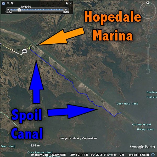
From beginning to end the canal is 14 miles long with its starting point on the north end at:
29° 49.061'N
89° 36.690'W
It terminates into the MRGO on it's south end at:
29° 42.523'N
89° 26.608'W
Why is this canal so important to inshore anglers?
It provides a straight shot from the marina to where speckled trout are biting during the summer pattern, specifically when the trout are biting good at the MRGO Long Rocks.
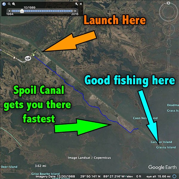
Especially when leaving from Hopedale Marina, the Spoil canal provides the fastest access to great summertime spots like Breton Island, Black Bay, Breton Sound and anywhere river water has receded.
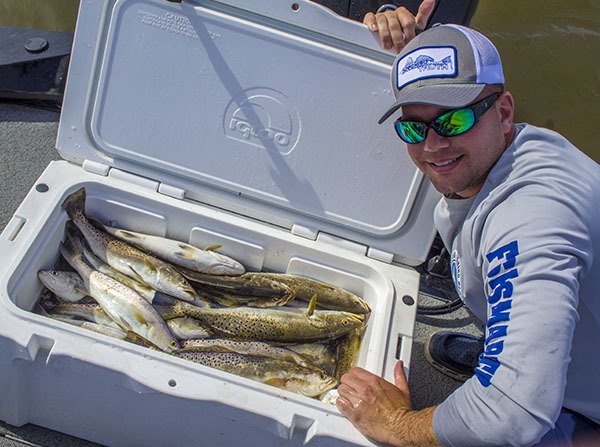
We all love catching speckled trout, and the Spoil Canal is the fastest way there.
So now you see why the Spoil Canal is so important to you as an inshore angler, but there's more you need to understand if you intend to run it, whether it's your first time or not.
Why is running the Spoil Canal so dangerous?
To say that the Spoil Canal is dangerous would be an understatement.
It can leave you stranded in the middle of nowhere, which is really just an annoyance, or cause something more serious, like a boating accident.
It has even claimed the lives of people who fell victim to its blind turns and shallow waters.
But to truly understand these dangers you must first know how the Spoil Canal came into existence.
Why was the Spoil Canal dug in the first place?
Old paper maps reveal that the Spoil Canal didn't come into being until the late 1960s, probably after the MRGO was completed in 1965.
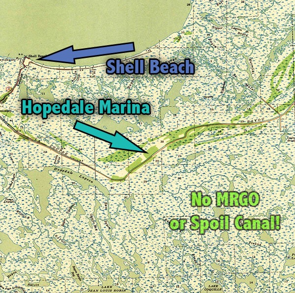
This map of Hopedale from 1941 shows how the marsh was organized -- naturally -- before oil companies and shipping interests ruined it.
This makes sense, because the MRGO was much narrower and, if you have any experience navigating around ocean-going boats and giant tugs, you really don't want to be in a large canal with them.
So it's a safe guess the Spoil Canal was dug to facilitate travel for smaller boats.
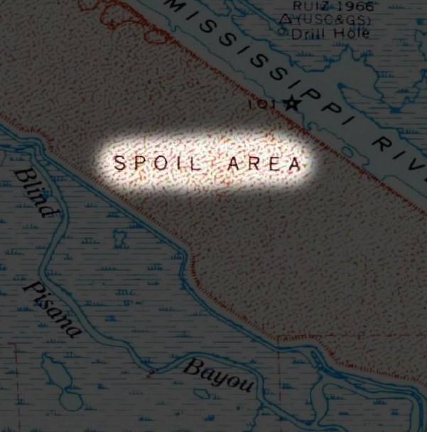
This map from 1969 reveals that when the canal was dug it had hard banks and its edges were easily recognizable.
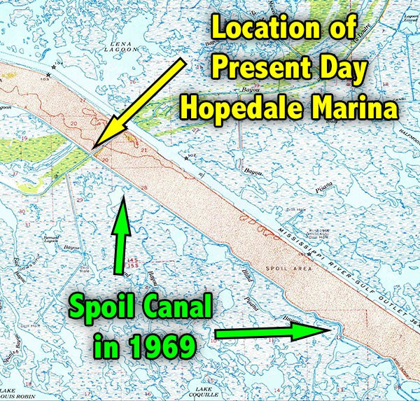
In fact, you can see why it is called the "Spoil" Canal because it ran next to all the spoil dredged from digging the MRGO.
The Perfect Storm For Boating Accidents
Now that we know how the Spoil Canal came to be, it's clear that several things have been created to create a boater's nightmare:
Let's detail each one:
Blind Corners
All that spoil from the MRGO makes for a high bank, one that creates blind corners.
The risk of a collision is increased when you can't see what's coming, right?
If you watch the video attached to this guide, you'll see what I mean.
Narrow Boat Lanes
Simply put, the Spoil Canal is not as wide as the MRGO, leaving less room for error when negotiating boat traffic.
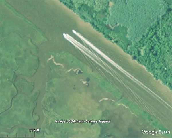
This Google Earth image from 2009 shows how narrow the Spoil Canal is compared to a much wider and easily navigated body of water like the Mississippi River Gulf Outlet.
Consider that some boats are slower, running 25mph, and others are considerably faster at 65mph.
Do you think the faster boat will run behind the slow boat for the entire length of the Spoil Canal? Probably not.
Certainly he would want to pass and, because there's not much room, that is when an accident can happen.
Shallow Water
Remember when it was dug? Yeah, over 50 years ago!
It's man made, hence the term "canal", and -- like all man made things -- will deteriorate if not maintained.
Not once have I seen a barge out there fixing banks or dredging the canal to depth.
Not once.
It comes as no surprise that a lot of the canal has eroded away, leaving it unclear as to where the channel is and silting in what is supposed to be deep enough to run a boat.
The Spoil Canal at Mulatto Bayou is a great example.
Mulatto Bayou 1989
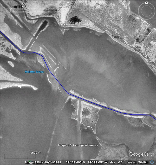
Note the path of the Spoil Canal (highlighted in blue), and how much of the bank still defines that path in 1989.
Now compare that to the more modern satellite image of 2016:
Mulatto Bayou 2016
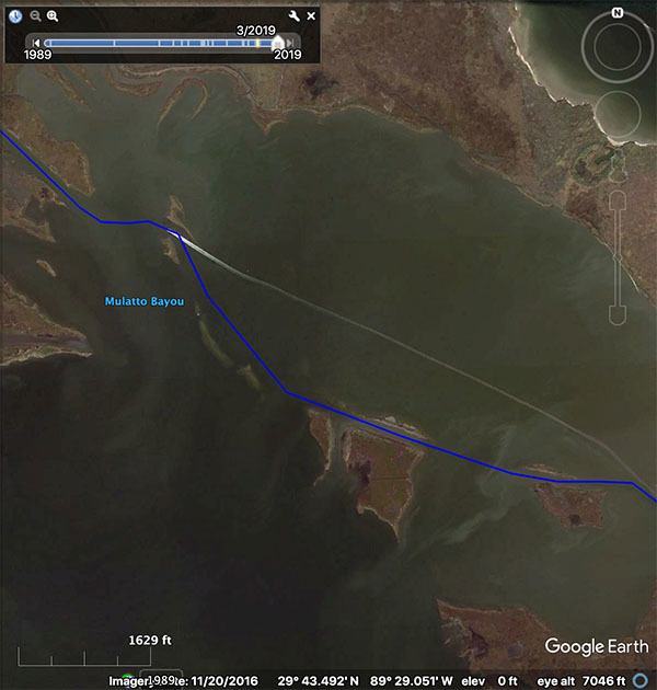
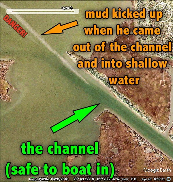
See the difference? It's even more pronounced when you're on the water.
Look closely and you'll see that's a crew boat in the 2016 image, indicating an experienced captain, who still missed the channel.
His saving grace (and why he didn't get stuck) were the double outboards propelling the boat across shallow water and soft mud.
That shallow pond grounds most boats and he narrowly escaped.
So now you see how easy it is to come out of the channel and enter dangerously shallow water.
Increased Boat Traffic
So why not avoid the Spoil Canal altogether?
Well, we used to!
We'd take the Mississippi River Gulf Outlet (or MRGO, pronounced "Mr. Go") to reach the "outside" of the marsh.
It was safe and easy to navigate because it was deep, wide and only required a couple turns to get to the Long Rocks.
That is, until it was closed off in 2009.
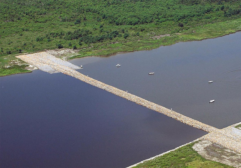
The Rock Dam closed off the MRGO in 2009. Today you must go around it.
Today the Rock Dam stretches across the MRGO, effectively closing it to boat traffic, leaving us with two choices:
- Going around the Rock Dam
- Taking the Spoil Canal
Going Around The Rock Dam
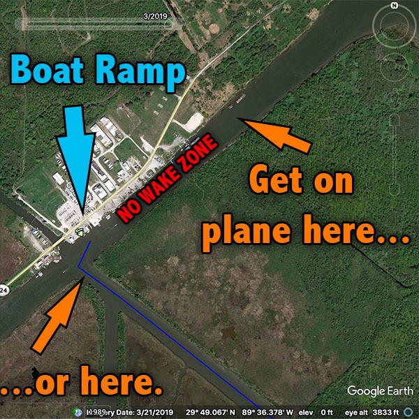
The route around the MRGO Rock Dam takes you through a short patch of marsh before emptying into the wide open (and easily navigated) waters of the MRGO.
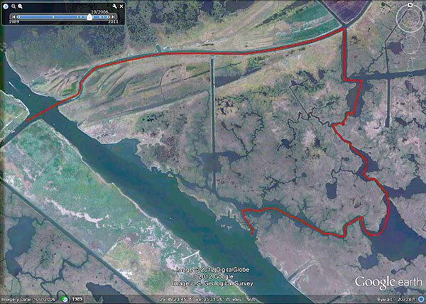
That would mean idling through a no wake zone, which could burn that precious morning bite if you didn't launch early enough.
Taking the Spoil Canal
Okay, we already know we can take the Spoil Canal, but the problem is that everyone else is too!
This means increased boat traffic in boating lanes that are already narrow and treacherous to begin with.
Throw in some crab traps, limited visibility and a bunch of people who have no idea where they are going and you have the perfect storm for boating accidents.
How To Safely Navigate The Spoil Canal
After reading everything up to this point the last thing you want to do is take the Spoil Canal to go anywhere.
Completely understandable.
Here's a tour of the Spoil Canal in my boat, so you can see exactly how it's done.
Yes, it's already posted at the top of this blog post, but I put here again so you don't have to scroll all the way up.
However, be sure to check out the rest of the tips in this guide!
Pay Attention To Those Markers
As you'll see in the video above, there are aids to navigation that have been installed for you to use.
They are dark grey in color and wider in diameter than PVC pipes used to mark oyster reefs.
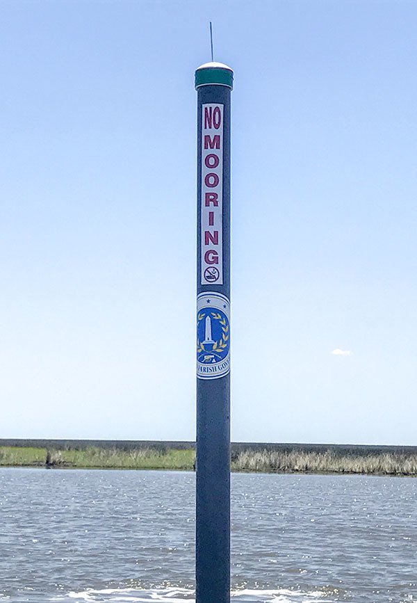
While they're nifty, they can never replace the resources below (so keep reading).
Use These Tracks
Here's a route plus a few points of interest you can use on Google Earth and even the GPS on your boat.
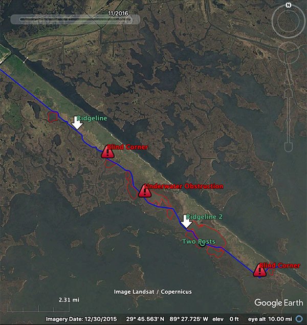
Convert them to whatever format your GPS uses, upload them and you're ready to go!
Enroll Inshore Fishing 101
The .kml and video above are pretty cool, but limited to one body of water.
The knowledge inside Inshore Fishing 101 will give you the ability to safely navigate anywhere in Louisiana's marsh and greatly reduce the risk of a boating accident.
In fact, there's an entire section dedicated to navigation and planning:
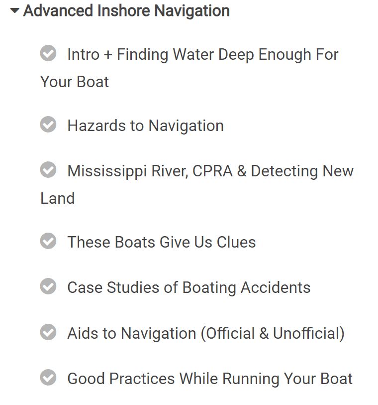
What you see there is a just a tiny bit of the curriculum.
There's more than navigational skills inside Inshore Fishing 101, there's the entire foundation of inshore fishing knowledge, giving you everything needed to catch fish on your own.
Over To You
These are all resources to help you safely navigate the marsh and catch more fish.
What's better than that?
But some bodies of water are more notorious than others, and the Spoil Canal is certainly one of them.
So, I hope this guide gave you the tools and knowledge you're looking for to negotiate not just the spoil canal, but other difficult waters as well.
If you have a question or simply something to add, then please do so in the comments section below.
Tight lines, and thank you for visiting my website!

You sure can!
I have a Sportsman Masters 247 with a 300 hp Yamaha outboard, a center console boat. Can I safely navigate the spoil canal to the long rocks in this boat? Thank you
No problem, Lance!
Thanks for taking the time to come back and reply.
I hope you have a good fishing trip out there, and be sure to post a report if you do go.
Tight lines!
I understand! Thanks for your reply and everything you do for us fishermen in southeast Louisiana! Your knowledge is priceless!
Hey Lance, I appreciate you taking the time to ask.
First off, please understand that what you do in your boat is 100% your responsibility.
After that, shrimp boats use the Spoil Canal, so why can’t you?
Just don’t come off plane and be aware how deep of water you’re in.
Finally, you’re a member of LAFB Elite (thank you for that) and you really ought to be using what’s laid here:
https://www.lafbelite.com/lesson/why-create-routes-with-google-earth-2/
Tight lines!
Would I be able to get a Bass Buggy pontoon through the shallow spots?
Thank you and good luck!
Enjoyed your learning video.Going to head out there this week and put some of it to use.
You’re welcome, Paul. I’m glad you watched and have taken the time to comment. Tight lines!
Thx for the help. Thx for the videos helping us become better anglers.
It’s about 14 miles.
How many miles is the run down the spoil canal?
It’s a DropBox link. Click it, then download the file.
I’m sure you already know this, but I gotta cover all the bases: .kml files are, by default, best opened in Google Earth, the desktop program, not the app.
Tried to download your “Download Spoil Canal 2019 .kml” but it doesn’t seem to work. Says it can’t be viewed. Is there a trick to opening the file?
Hey John, thanks for commenting.
Honestly, it depends and it’s best to cover water to see where they are holding.
You’ll see everyone fishes the west side, but that doesn’t necessarily mean it’s the best.
Those people are fishing there because that’s what they were told, or what they saw.
You are far better off using what’s inside IF101 and covering water.
Thanks, John
Sorry to hear that, Alton.
As far as the other route goes, you can see more info on that here:
https://www.lafishblog.com/route-around-the-mrgo-rock-dam/
Thanks, Alton!
What are the best areas to fish along the long rocks at the end of the spoil canal?
Hey Devin, I like your video, I tried it one time with standard mapping got to one point as I was following the yellow line the line separated,
one to the left and one straight I didn’t know so I stayed left, wrong yellow line ran out. anyway I notice most of your trip was in a straight line compare to the obstruction when I tried. when you turn into Mr. go I could not tell just looking like open water. which way would be toward the rock dam.
Hey Larry, thanks for commenting and I’m glad you liked this video.
A Humminbird Helix 7 and Louisiana Delta card will do you good, as well as a Lowrance HDS w/ a Standard Mapping Card.
Thanks.
Hey Devin i’v Never run the spoil canal just by what i’ve heard about it by watching your video I might try it gonna watch it a couple more times when you stopped at the end where you close to the long rocks heard a lot about them gonna buy me a fish finder gps unit which is the best to get and card love watching your videos