Ever since the closure of the MRGO Rock Dam anglers have been faced with the challenge of going around it.
In this guide, you will learn the options for meeting that challenge.
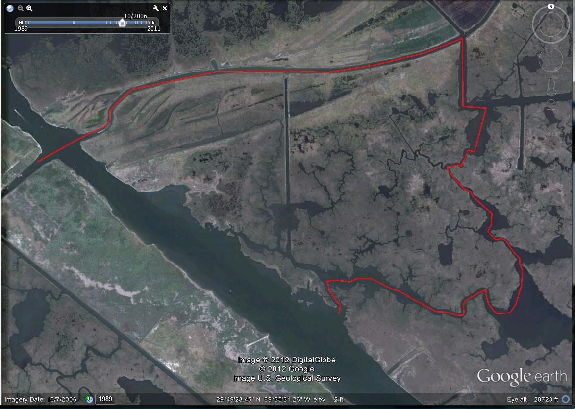
Way around the MRGO Rock Dam
The graphic below outlines how to get around the Rock Dam going across the MRGO (Mississippi River Gulf Outlet).

Click to Enlarge
Frequently Asked Questions About The MRGO Rock Dam
Sometimes people have more questions than just wanting to know how to get around the rock dam. Here they are:
How long is the Brady Lagoon route around the MRGO Rock Dam?
The green route through Brady Lagoon is approximately 8.3 miles long.
Is there another path if Brady Lagoon is too shallow?
Yes, you can go through Little Halfmoon Bay and reconnect with the original route at Bayou Pisana.
This alternate route is colored yellow in the above graphic.
Or you can take the Spoil Canal instead.
Where can I learn to make routes like the one in the picture?
While there are more than a few resources on the Internet, this module inside Inshore Fishing 101 completely breaks down how to safely navigate Louisiana's marsh, specifically:
- how to identify safe water
- how to detect shallow water
- avoid navigational hazards
- create custom route
- upload them to your GPS
When was the MRGO Rock Dam built?
This dam was built in 2009 by the Army Corps of Engineers in order to decommission a failed ship canal providing access to New Orleans.
Construction started in April of that year, and was completed in August.
Do you have a .KML for the MRGO Rock Dam available for download?
I sure do! Just click here to get the file list you see below.

Conclusion
You can have the best honey hole in the world, but it's no good if you can't safely get there (and back).
Hopefully this tidbit of information has helped you and you are able to enjoy a good fishing trip on the other side of the MRGO Rock Dam :)

Unfortunately, no. But it’s not a far paddle in a kayak.
can u drive a car to hopedale rock dam
Hey Ricky, without pulling it up on Google Earth I couldn’t tell you (I’m not near my laptop). I’m sure the extra distance isn’t a deal breaker in any sense, as I doubt it’s more than a couple miles.
Anyway, if you don’t use Google Earth Pro, you really should consider doing so. It’s helpful for more than just measuring distances, but also finding fishing spots, water safe to navigate and creating custom GPS routes, something I cover in-depth inside Inshore Fishing 101.
As for your other question, either one. It depends on you and what you’re comfortable with, as described in the video.
After all, nothing beats time on water, but this video will help you make the most of it.
Thanks for commenting!
Great video. Never been on that side of the dam. Is the yellow route Bakers canal and how long is that route? Is it also shallow? Which route is best/safest for a 21’ Bay boat?
Hey Reid, thank you for the compliments! I’m glad you enjoyed IF101.
Your question is a broad one, but I will do my best to answer it, first covering conditions then fishing strategy:
So, whether or not is best really depends on a lot of variables.
After all, if it were as easy as “fish this spot during X tide”, then Inshore Fishing 101 would be reduced to a giant spreadsheet with locations in one column and another column indicating which tide is best to fish them on.
But that’s not the case, and never will be.
Time of year, primary forage, what you want to catch, salinity, trending conditions, and a lot of stuff that’s really just too much to list here is what you have to consider.
We’ve smashed the trout with NO TIDE on the south side of the rocks, and that was during the winter. So what does that say about fishing a rising tide?
That’s why you really need to use something like the LAFB Elite Community. Make a post about your upcoming fishing trip, so we can tie it all together based upon specific conditions.
Inshore Fishing 101 is good, but it’s only the foundation, just like the foundation of a house: the house cannot stand without it, but by itself it is not a house.
With that said, why is it so important to game the tide for a specific spot to make the decision as whether or not to fish it?
There’s more to fishing than knowing conditions, and strategy and judgment calls are two of those items.
Consider this: If you’re running past the south side of the MRGO Rock Dam, then why not stop and give it a few casts as per the Elements of Effective Fishing?
Will doing so completely derail your fishing trip?
I don’t think so.
Now consider this: If you want to know if a rising tide is best or not for the south side of the Rock Dam so you know if you should even bother fishing it or not, then what are you going to do when you get there and no fish are there at all?
Because it absolutely happens that conditions can be “perfect” and fish won’t be there at all.
So now you made that 8+ mile run with no idea as where else to go since the ONE spot you gambled on completely bombed.
That’s more likely than not, and why no professional angler ever hangs his/her charter or tournament on one fishing spot. He has more than one and, if you watch Inshore Fishing 101, you’ll see how I pick fishing spots based upon the conditions and you’ll see that it is ALWAYS more than one fishing spot (about a dozen picked out).
Have there been times I’ve only fished one spot all day? Yes. But those are extra-special circumstances that are the exception that ultimately proves the rule: don’t gamble it all on one fishing spot.
Lastly, consider this: Let’s pretend I did say “yes, a rising tide is best” to fish the south side of the Rock Dam. Well, let’s say that on a hypothetical fishing trip you are on, you have run all over creation and not caught a single fish. You are hurting and really want to go home with something to show for your effort. So you’re running past the south side of the Rock Dam and think about fishing it, but it’s obvious the tide is falling and not rising.
Will you keep going? Or will you stop and give it ten minutes of your time?
I think you’d be crazy to not try.
Anyway, that’s a long response and I hope you didn’t find it too much to read and, above all, that it answers your question.
Tight lines
Devin, I appreciate the knowledge and your willingness to share the best routes. I recently completed Inshore101 and the material was presented perfect. Thanks for dropping#knowledgebombs daily.
Is it best to fish the SE side of the rock dam on a rising tide or does it matter due to the depth of the canal? This is assuming the wind direction is ideal.